[page 1] [page 2]
[Next Page >]
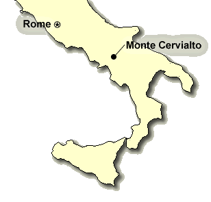
This section more completely documents our climb of Monte Cervialto. Monte Cervialto is the highest in a range of mountains (called the Picentini Mountains) that lie close to my mother's home town of Avellino. I thought it might be nice to explore some of the mountains in which my relatives grew up.

Avellino and Monte Cervialto both belong to a Irpinia sub-region of the province of Campania. The area is characterized by rolling limestome mountains and flat plateaus. In order to reach Monte Cervialto from Avellino, one travels east, towards the litte town of Bagnoli Irpino, and from there up to a high plateau called the piano Laceno. From here, it is a short drive to a wooded pass where CAA trail #13 takes you to the summit.

Note: additional pictures on these pages that are not in the main narrative have a thumbnail surrounded by a color.
Locator Map for Monte Cervialto
This is a regional locator map for Monte Cervialto. Avellino is located to the left of the map, north of Salerno. [enlarge]
Bagnoli Irpino
A quaint town in the countryside near Avellino. I had relatives who owned a house here in this town, and when I was young, I stayed here for a short while. [enlarge]
Town square, Bagnoli Irpino
[enlarge]
Town Square, Bagnoli Irpino
[enlarge]
Cattle, Piano Laceno
Cattle on the road in the scenic Laceno area, Appenine mountains, Italy. Taken on the way to climb Monte Cervialto. [enlarge]
Cattle, Piano Laceno
Cattle on the road in the scenic Laceno area, Appenine mountains, Italy. Taken on the way to climb Monte Cervialto. [enlarge]
Lago Laceno
This is Laceno Lake, a popular tourist destination in this part of Italy. However, there is very little left of this lake - just this little bit of muddy water at one corner of a valley plain. [enlarge]
Monte Cervialto
This is monte Cervialto, the highest peak in the region surrounding Avellino. It has an altitude of 1809m, or about 5900 feet. [enlarge]
Roads around Monte Cervialto
Lots of interesting little winding roads near Monte Cervialto. [enlarge]
Cattle silhouettes near M. Cervialto
[enlarge]
Trailhead to Monte Cervialto
The start of the trail (old road, for the most part) to the summit of Monte Cervialto. [enlarge]
Andrew on trail to summit
Andrew on the trail to the summit of Monte Cervialto. [enlarge]
Jenn on trail to summit
Jenn reaches one of the first lookouts on the trail up to Monte Cervialto. [enlarge]
Interesting dried plant
[enlarge]
Interesting plant, flipside.
[enlarge]
Overgrown trail
The trail gets a bit overgrown as it nears the top of Monte Cervialto. [enlarge]
Beautiful open wood
A section of nice open wood on the way to the summit of Monte Cervialto. [enlarge]
Leaving the trees,
We finally reach the point at which the trail emerges above treeline, which in this area of Italy appears to be at around 5500+ feet. [enlarge]
Mountain Wildflowers, M. Cervialto
[enlarge]
Jenn in open meadows
Jenn climbs through the grassy / rocky meadows to the summit of Monte Cervialto. [enlarge]
[page 1] [page 2]
[Next Page >]

[ Italy 2005 trip home page | The main trip report | Family | Monte Cervialto | Herculaneum & Vesuvius | Palace of Caserta | Amalfi & Capri | Abruzzo & Monte Amaro | Rome | Tuscany | Venice | The Biennale | Via Ferrata-ing in the dolomites | Climbing in the Ortles | Gottfried's Adventures | Maps, Graphs & GPS Data ]

Send feedback or leave comments (note: comments in message board below are separate from those in above message board)
(23 messages)
(last message posted on Sun. Nov. 20, 16:43 EST 2016 by Britany Wilson)
Web Page & Design Copyright 2001-2024 by Andrew Lavigne. (Privacy Policy)