It was a few minutes before noon as we arrived at the Aster Lake backcountry campsite. The campsite was not actually right at Aster Lake, but rather along Aster Creek about 200 metres below the lake. In addition to the brilliantly-colored outhouse, the campsite also offers a sturdy set of bearproof food boxes. Very useful in grizzly country such as this.
Aster Lake backcountry campground
Aster Lake Backcountry Campsites
Interactive trackmap with photo points - U. Kananaskis Lake to Aster Lake CG - click map to view
Upper Lake TH to Aster Lake - Hike Data
Start Time:
6:21a.m.
End Time:
11:59a.m.
Duration:
5h38m
Distance:
10.57 km
(6.57 mi)
Average Speed:
1.9 km/hr
(1.2 mph)
Start Elevation:
5623ft
(1714m)
*
Max Elevation:
7369ft
(2246m)
*
Min Elevation:
5623ft
(1714m)
*
End Elevation:
7369ft
(2246m)
*
* : +/- 75 feet
Total Elevation Gain:
2034ft
(620m)
*
Total Elevation Loss:
346ft
(105m)
*
* : +/- 75 feet
Elevation Graph
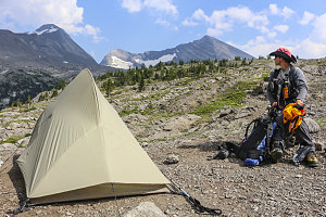
There was only one group currently at the campsite, and they were preparing to leave. Therefore, we had the pick of any of the sites. The sites are a mixture of grassy spots near the trees and near the creek, and some more open gravelly sites a bit higher up. We chose a higher up site for a nicer view.
Our camp was set up before 1pm, and, as a result, we had a lot of free time left in the day. We had two options: we could go for a mountain summit today, and then spend an easy day tomorrow hiking back down to the trailhead, or we could lounge around and relax for the rest of the day around Aster Lake, then get up super early and summit a peak the next morning, returning back to the trailhead in the afternoon.
Set up at Aster Lk Campground
We hummed and hawed about this for some time before ultimately deciding not to go for a peak today. The weather forecast is what ultimately decided, really. Like almost every other day over the past seven days, the forecast called for instability in the afternoon, with the possibility of a shower or thundershower. Having seen several such thundershowers happen on previous days, we decided the most prudent course of action was to climb in the morning, when there was virtually no chance of precipitation. So, even though the weather seemed quite nice and not threatening at the moment, we simply lounged about - although, when one thinks about it, lounging around on a soft alpine meadow on a warm afternoon isn't so bad.
After dozing off for a while, I decided that I needed to get the blood flowing at least a little bit, and so I set off to hike to the top of an open hill just to the north of Aster Lake. It looked like the view from the top of it would be quite expansive, and perhaps even give us a bit of extra info on whatever objective we chose to climb the next morning.

courtesy JInnes
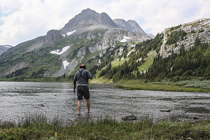
Crossing the outlet
After a chilly crossing of Aster Creek and a quick ascent of the hill, I was indeed presented with an expansive view of the surrounding landscape. To the south and west I had a clear view of the crest of the continental divide, along with slabby Warrior Mountain and Cordonnier Peak, one of which (or perhaps both) we were planning to climb the next morning. According to my scrambling guidebook, the "crux" of the climbing to these peaks was a crossing of a remnant bit of glacier clinging to the flank of the crest between Cordonnier and Warrior. It certainly looked stagnant from this vantage point, and it also had a border of snow surrounding a central section of exposed ice. This was important to our plans: we had chosen not to bring crampons, and we needed a border of snow upon which to climb.
Having finished with examining points west, I turned my attention to the east. In this direction was a clear view down to Kananaskis Lake, although I say clear with qualification: the air was so hazy that the lake and the mountains beyond were half-hidden in the murk. It certainly wasn't one of those crisp, clear mountain air sort of days.
Ridges and snowfields of Mt Lyautey
Down to Upper Kananaskis Lk
Aster Lake campground situational
After returning back down to Aster Lake, Jenn and I retired back to our scenic little campspot, and after some more warm afternoon napping, made some dehydrated meal dinners and made ready for an early turn-in. The plan was to start our climb before dawn, which would allow us to complete our hiking day hopefully by mid-afternoon. We didn't want to arrive back too late because the next phase of our Rockies 2014 trip involved travelling up to Lake Louise in Banff (and meeting up once again with Cassándra - our weekend hiking companion!).

courtesy JInnes