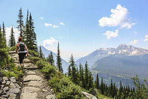
Jenn and Cassándra headed out from the Chalet shortly thereafter. The rest of us took a bit longer to get moving, but soon we too were walking back down the rock staircase to the junction with the Highline Trail. We could trace the thin thread of the path as it trailed far off, along open slopes to the south. Mostly, it looked flat and easy. And busy. We could see many, many hikers on the trail. Unlike the last 2.5 days of hiking, this part was going to be busy!
Blades of the Garden Wall
After about forty minutes of hiking, we were surprised to see Jenn and Cassándra just a short way ahead of us. This seemed strange, since they had started out ahead of us and were clearly faster than the rest of us. We hustled to catch up to them, and were about to claim slowpokes on them, when they explained that they had stopped to administer first aid to an elderly hiker that had tripped and cut up her face. A suitable explanation.
Jenn and Cassándra slowly pulled ahead as we continued on.
The next hour or two was a very pleasant jaunt across the sloping terrain below the Continental Divide. The trail curved into a shallow drainage basin, out around a buttress or point, then back into the next shallow drainage basin. As a result, there was always something a bit different to look at.
Rounding a Prow of Bedrock
The weather was perfect, with no sign of rain clouds building, and we nearly always had open views up to the jagged crest of the divide (this section of which is known as The Garden Wall), and far to the west, down into the valley of McDonald Creek and beyond. Once in a while we would briefly pass through a sliver of forest clinging to the slopes.

courtesy JInnes
Cassándra on the Highline Trail
Beargrass and the Mountains
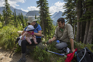
Despite this being probably the longest hike with the most elevation gain that Gillian had ever done, she was moving along at an excellent pace, and we were making quite decent progress. I'm absolutely positive this was the longest hike five month-old Evie had ever done, and she also was doing remarkably well. The few mild complaints we heard from her rarely lasted for more than a minute or two, with perhaps the exception of the periods immediately preceding feeding time (of which there were two post-lunch, I believe).

Food Break
Having such a young infant along certainly attracted many comments from fellow hikers - far more than I'd ever heard on any other hike. There were many "How Cute"'s and "So Sweet"'s, along with several variants of "That's Brave" and "Good for you". Generally speaking, positive stuff.
We rounded a buttress and began a long gradually rising traverse (up to this point, the Highline Trail had been fairly close to flat). This long rise gains about 650 feet of elevation (about 200m), and brought the Highline Trail out of the grassy alpine zone into a zone more dominated by bare rock and scree. The trail is a bit more airy, more exposed here, with steeper slopes and minor cliffs both above and below the trail. At all points, however, the trail was well graded and easy to walk on. I could tell Gillian was getting a bit weary along this stretch.
Just beyond the high point (in fact, the highpoint of the entire length from Granite Park to Logan Pass), we stopped for a bit to filter some fresh and cold mountain water from a splashy little waterfall that crossed the trail.
After the highpoint, a long gradual descent began. Haystack Butte, an outlier peak west of the Garden Wall, loomed much bigger and closer now. We could see our track, as it descended to a snowfield in the col between the butte and the Garden Wall. An obvious trail led west and down in front of the butte, but I knew this had to be a false path, for we knew the Highline trail ended at Logan Pass - and down in that direction was not Logan Pass.
Instead, the Highline Trail crossed the snowfield across the lowpoint between Haystack Butte and the Garden Wall (our only snow crossing of the day - an easy crossing, since it was completely flat), then did a pretty zig-zag descent down a grassy meadow filled with beargrass. Below this, the trail resumed its usual southward-on-the-level course.
With Grandeur as a backdrop
Col behind Haystack Butte