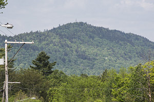
Goodnow Mountain is a very modest peak close to the hamlet of Newcomb, NY, on the southern fringes of the Adirondacks High Peaks Wilderness. It normally wouldn't be of all that much interest, but it so happens that there is a very nice fire tower on Goodnow, along with an official NYSDEC hiking trail. The fire tower is open to the public and there are a number of other historic buildings on and near the summit.

Goodnow Mountain
This hike up Goodnow was part of a weekend I spent on an Alpine Club of Canada outing to climb Mount Allen. We had completed the
Allen hike the day before, and the hike up Goodnow was an idea by trip leader Grant to round out the weekend with something easy and short. However, after the long and arduous journey to Allen, most of the group (well, everyone except for myself and Grant) had declined the opportunity to hike Goodnow.
Hiking Goodnow Mountain is easy and straightforward. It is very short (around 4 miles / 6.3 km roundtrip), and very close to the town of Newcomb and to Lake Harris State Park, which is located just outside of the town. Grant and I got up nice and early and we were at the trailhead right around 6 a.m.
After signing-in at the completely empty trailhead, we started up. The trail was wide and well-marked. It lead steeply uphill for a minute or two, then turned sharp right and began a long contouring path to the west, around the northern base of the peak. In places, it actually went slightly downhill before finally turning south and climbing gradually towards the mountain's main east-west ridgeline.
The trail was very wide and virtually entirely dry (very little mud). In most flat locations where mud could develop, there were well-placed and well-constructed planks and boardwalks.
The trail curved back east as it gained the main east-west ridgeline of Goodnow Mountain. In a few places there were minor steep or rough bits, but only briefly. We proceeded at a brisk and constant pace and were not at all hindered by trail or terrain.
We began to see the remnants of old structures as we neared the summit elevation, and the trail began to flatten out as we reached the upper levels of the ridgecrest. The forest at these highest points began to transition away from deciduous trees (this is a low peak, so most of the forest on it is mixed or mostly deciduous). A few little ups and downs on the ridgecrest (still in tall forest) brought us to a final climb to the summit clearing, where the Goodnow Mountain fire tower stood. It appeared to be in very good condition.
The tower seemed taller than other similar Adirondack structures as we climbed the flights up to the cabin (although that could simply be an inaccurate recollection on my part). From the top, we were presented with a superb 360-degree Adirondack panorama. Early morning ground fog had not yet burned away from low-lying areas, presenting us with delicate, sublime views.
We loitered for quite a while, enjoying the scene and taking the first real rest break of our hike. A slight breeze helped dry off the sweat from our brisk one-hour walk (roughly the time it had taken us to climb up from the trailhead).
After fully enjoying the fire tower's excellent attributes, we climbed back down and had a quick look at the historic caretaker's cabin. It was fully weathersealed and locked, and peering inside, seemed to retain much of the furnishings and equipment from the early 1900s.
We then retraced our steps back down to the trailhead in about forty-five minutes, arriving shortly before 8:30 a.m. I'm glad Grant convinced me to do Goodnow. It is an excellent little peak with a straightforward trail, a superb fire tower, and excellent fire tower views. This hike should definitely be on anyone's list of short Adirondack hikes. In short, I can honestly report that Goodnow mountain is quite good, now that I have done it. Ha... see what I did there?

Brilliant Cemetery Flowers
We drove back to our campground at Lake Harris, where the remainder of the weekend hiking group was just getting ready to depart. After shaking hands and splitting up into two vehicles, we began our drive back to Ottawa, satisfied with having completed a fine weekend of hiking in the Adirondacks.
Interactive trackmap with photo points - Goodnow Mountain - click map to view
Goodnow Mountain - Hike Data
Start Time:
6:15a.m.
End Time:
8:27a.m.
Duration:
2h11m
Distance:
6.35 km
(3.95 mi)
Average Speed:
2.9 km/hr
(1.8 mph)
Start Elevation:
1481ft
(451m)
*
Max Elevation:
2696ft
(822m)
*
Min Elevation:
1481ft
(451m)
*
End Elevation:
1677ft
(511m)
*
* : +/- 75 feet
Total Elevation Gain:
1113ft
(339m)
*
Total Elevation Loss:
944ft
(288m)
*
* : +/- 75 feet
Elevation Graph
