The Evangeline Trail
Friday, July 11
Friday was the day that we got to experience 'the CAT', a large ferry with a catamaran-type hull. It is able to reach fairly fast speeds for a ferry -- between 65 and 75 km/hr, and promised us a crossing time of about 5 hours for the 300+ kilometre ride across the Gulf of Maine. We were taking this ferry to give us a nice, straight-line crossing over to Yarmouth, Nova Scotia, where we would then begin our journey along the backbone of Nova Scotia.
The ferry was scheduled to leave Portland that morning at 8am. Even though we had booked a ticket in advance, we didn't know how picky they were about getting in line before departure, so to be sure, we were in line an hour before. The morning was sunny and warm, and we waited patiently in line with the big shiny CAT visible to our right. To our left was the city of Portland, which looked like a decent place from this angle.
The CAT has a 'folded' (for lack of a better word) parking area, meaning that you go in, do a 180-degree turn, and then head back out (i.e. vehicles are parked in an elongated 'U'). There's no disembarking from the front of the CAT, with it's front end being designed for high speeds and all.
The passenger deck of the CAT was pleasant enough. Spacious, with all of the usual amenities. We headed for the back, where the only passenger-accessible outdoor area is located. This is basically a 10-foot deep strip that runs across the stern of the boat. There's no outside access to the side, front, or top of the boat.
We stood out back on the narrow deck anyway. I wanted to see what kind of wake would be produced from a vessel as large as this travelling at 30 or 40 knots. Initially, we slowly burbled out of Portland's Harbour, past other ships and pretty coastal lands. Only after 20 minutes or so of this did we reach open water and the captain leaned on the throttles. Two fairly impressive rooster tails of water jetted back, and soon we were cruising along at around 35 knots (64km/hr) -- somewhat under the maximum, but still decently fast. A regular ferry would take much longer to make this crossing.
When the excitement of watching the wake wore off, we returned inside, where I did a little bit of web work on the laptop, and Jenn read her book. We also toured around the inside of the ship, noting how much quieter (but somewhat more choppy) the bow of the boat was.
The crossing took almost an hour longer than scheduled (perhaps due to not operating at maximum speed?), and we arrived in Yarmouth, Nova Scotia at around 3pm local time (crossing into Nova Scotia meant advancing the clocks 1 hour to Atlantic Daylight Time). As we slowly made our way into port, we cruised past some open grassy coastal lands, complete with a few twisted fir trees and colorful seaside houses with clothes on clotheslines, blowing in the sea air. Jenn felt that her stereotypical image of the Maritimes had just been confirmed!
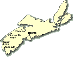
Safely back on land in the port town of Yarmouth, largest of the towns along this extreme southwestern end of Nova Scotia's main peninsula, we headed north on highway 101. The 100-series highways are Nova Scotia's main arterial highways, and typically bypass communities. We wanted to see the land, towns, and culture, so it wasn't long before we veered off highway 101 and onto highway 1, which more closely mirrored the coast. Highway 1 from Yarmouth through to the end of the Annapolis Valley is known as The Evangeline Trail, and our plan was to follow that for most of the day and for most of it's length.
Highway 1 north of Yarmouth leads through a section of coast called the French shore (or sometimes called the 'Clare shore'). It is a string of french-Acadian communities -- one of several pockets of french Acadian culture that are scattered about Nova Scotia. The drive through here was quite pleasant, and reminded me of the Acadian shore of northeastern New Brunswick (which is close to my original home town).
Approaching the French Shore
We drove through many small french communities -- Meteghan, Mavillette, Saulnierville, and Point de L'eglise, to name a few. Characteristic of this region were: open grassy fields leading out to sea; colorful rustic houses with the tricolor-and-star of the Acadian flag proudly fluttering, and grand churches -- mostly of them entirely constructed of wood. The most impressive of these was the gracefully tall church at Point de L'eglise -- apparently the largest wooden church in North America.
Heading towards Point de L'eglise
Interior, St. Mary's Church
Leaving the French shore, we started to transition to the region of the Annapolis valley. Sandwiched between the long straight escarpments of North and South Mountain, the Annapolis valley is famous for it's apple orchards. I consider the valley to be the breadbasket of Nova Scotia. There is intensive farming here.
Just before entering the valley proper, though, we stop at the historic, sometimes-french, sometimes-british community of Annapolis Royal. There is a very pretty National Historic Site here -- Fort Anne -- a partially preserved fort that was used initially by the french, but later taken over by the british. The fort is interesting in that it is a star fort, utilizing earthen barriers in a complex geometric star-like shape. Jenn and I stopped to explore, walking the steep grassy hillsides of the fort, exploring the 300-year-old gunpowder houses, looking out from the commanding overlook of the Annapolis Basin, and learning about the history of the place from the museum within the restored Officer's quarters. Everything but the museum is free of charge, and I highly recommend the fort as a refreshing and interesting diversion.
Reading about the Powder Magazine
Exploring the Powder Magazine
From Annapolis Royal and Fort Anne, we entered the Annapolis Valley and drove through farming communities and past orchards, eventually making our way to the eastern end of the valley, where the communities of Kentville, New Minas and Wolfville are located. This area was my home for over 4 years as I attended university in Wolfville.
It was getting late, and we wanted to camp. I knew of a provincial park on a high bluff of land at the eastern end of the long North Mountain: Blomidon Provincial Park. We made our way to the very northeastern end of the Annapolis valley and climbed the steep slopes of North Mountain to the park's entrance.
Blomidon Provincial Park's campground is not situated not far from the edge of Cape Blomidon itself. From the main part of the camping area, you can see an expansive view across the Minas basin. We set up our tent and took a short walk along the excessively mother-henned walking trail along the cliffs (read: it mostly goes nowhere near the top of the cliffs). I captured one decent view from one tiny sort-of lookout, and then in the deepening dusk, we turned around and headed back to our tent. It had been high overcast all day, but now the pre-sunset light was streaming in from the west, creating all sorts of weird tints and glows around us. I tried to capture the sense of the fantastic colors in the pictures below.
Interactive Trackmap & Photo Points - Click map to expand

 Introduction
New England Shortcut
The Evangeline Trail
Cape Split and Cape Breton
Nova Scotia's Highpoint
The Cabot Trail
Prince Edward Island
A Tale of Two Visits
Family Business
Introduction
New England Shortcut
The Evangeline Trail
Cape Split and Cape Breton
Nova Scotia's Highpoint
The Cabot Trail
Prince Edward Island
A Tale of Two Visits
Family Business
 In-depth: The Hancocks Hike
In-depth: The Cape Split Hike
In-depth: White Hill Climb (NS Highpoint)
In-depth: The PEI Highpoint
In-depth: The Hancocks Hike
In-depth: The Cape Split Hike
In-depth: White Hill Climb (NS Highpoint)
In-depth: The PEI Highpoint