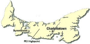
PEI's summit is an unnamed height-of-land in an area of farmer's fields located roughly halfway between the cities of Charlottetown and Summerside. It does not have any sort of official trail leading to it. At just over 500 feet above sea-level, it isn't the sort of place that requires supplemental oxygen. And at less than half a kilometre of walking distance from where you can park, it is the sort of place that you can knock off in half of an afternoon.
It actually took us two attempts to bag this highpoint (ok, so we only gave the first try 40 minutes or so... but I thought it'd be easier).
This highpoint trip was part of a larger trip to the Maritime provinces that Jenn and I took in July of 2008. If you'd like to read about that trip, complete with many pictures and maps, please
click here.

Shady access road
The closest approach to the highpoint is along PEI provincial road #227 (also called 'Junction Road' in the vicinity of the highpoint) not far southeast from where 227 crosses PEI provincial road #264. The section that goes nearest the highpoint is gravelled (although well-packed), and dark and leafy in the summer. The approach from the northwest contains the least amount of gravel road driving (maybe 500 metres' worth).
We parked at an opening to a large field near the waypoint we had programmed into our GPS for the highpoint.
We first walked south along the edge this open field, crossing over what appeared to be the highest point on it without any indication of a high point [marker].
Andrew explores the first candidate
We then retraced our steps and walked back along the road [northwest, that is], noticing a very faint overgrown road leading off into the woods. We headed down that for a bit but didn't see anything obvious. Elevation readings from my GPS showed it to be about the same as the highest point in the field we were just in. And still, no marker or sign. Ok... not quite so easy as it sounded! Back again to the road, we walked along it [again, further northwest] for a hundred yards or so to a point where another field to the south became visible. According to my GPS, it too appeared to be very similar in elevation to the other two spots, so we spent a fair bit of time combing the highest point of this field, which appeared to be at the edge of the field where it met the edge of the aforementioned woods.
After several tens of minutes of searching the edge of the field and in the woods, we finally came across a government 'there is a survey marker near here' sign, and, not too long afterwards, a solitary survey marker. Was this the highpoint? It was right at the boundary of field and wood, and it had an arrow on it. It looked more like a triangulation marker for another survey marker nearby, but we could not locate another survey marker in the direction in which it pointed. It was promising, but I was unconvinced. Besides, based on where it was, it could simply be the survey marker for the boundary of the field. And, once again, elevation readings revealed that this point was unconclusively at the same general altitude as the other two spots.
Is this the highpoint marker?
Interactive Trackmap & Photo Points - PEI Highpoint unsuccessful - Click link below to expand
We had a dinner appointment that evening, so we had to leave without conclusively finding the highpoint.
We returned the next day, armed with a bit of extra information after stopping at an internet access point and doing a further bit of research. The faint overgrown forest road that we had only partially explored the day before looked like it was in fact the correct route to the highpoint, which was indeed marked with a dinstinctive mailbox marker.
We returned to the leafy little red road and parked the car at a pullout, this time aiming to fully explore the faint old overgrown road. We headed down it, very carefully looking for some sort of indicator or flagging that was a 'couple of tenths of a mile' along. With a bit of careful looking, we did indeed spot some flagging tape, and quickly saw some additional flagging leading off to the west.
It wasn't long after that we arrived at the elusive gold mailbox. Mounted on a steel pole, the little mailbox was ringed with a few faded bits of flagging, and inside, a bagged PEI highpointers log! Pretty definitive, and I was glad we had come back. In fact, even if this wasn't the actual highpoint, we definitely had reached it somewhere along the line. Over the previous day and today, we had pretty much scoured the whole square kilometre of terrain and visited all of the points indicated by all of the different reports about visiting PEI's highpoint (i.e. the field, the survey marker, and the highpoint mailbox).
After leaving an entry in the logbook, we headed back to the car and headed towards the Confederation Bridge and New Brunswick. This was the first time I had used the bridge, seeing as the last time I was on PEI was before they had built it. Quite a remarkable structure!
Interactive Trackmap & Photo Points - PEI Highpoint successful - Click link below to expand
Hike Data - Walk to PEI Highpoint
Start Time:
4:21p.m.
End Time:
4:51p.m.
Duration:
0h30m
Distance:
0.82 km
(0.51 mi)
Average Speed:
1.6 km/hr
(1.0 mph)
Start Elevation:
448ft
(137m)
*
Max Elevation:
477ft
(145m)
*
Min Elevation:
448ft
(137m)
*
End Elevation:
457ft
(139m)
*
* : +/- 75 feet
Total Elevation Gain:
16ft
(5m)
*
Total Elevation Loss:
11ft
(3m)
*
* : +/- 75 feet
Elevation Graph
Here are some important waypoints for the trek to PEI's highpoint. Please note that all co-ordinates are in the WGS84 datum. A full tracklog with the waypoints is available from the link in the sidebar on the left. Also, please refer to the above interactive trackmaps for further information and details (double-click them to see more detailed tracks and to see photo points).
- Car Parking option #1 (small pullout in forest): N46.334352 W063.419429
- Car Park option #2 (pullout and edge of open field): N46.333674 W063.418502
- Start of faint old forest road: N46.334171 W063.419249
- Flagging leading off towards summitbox (waypoint FLAGGING): N46.331241 W063.418619
- Summit box (waypoint SUMMITBOX): N46.331125 W063.419002
