Return to alavigne.net home
Maps and Elevation Profiles

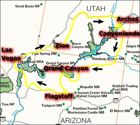
On this page you will find various Maps and Graphs pertaining to our trip. This first map immediately below is an overview of our trip, highlighting the areas that we visited. Further below are [enlargeable] maps and graphs from our hikes.


Overview Map
Emerald Pools and Observation Point Topo
Emerald Pools Hike, Elevation over Distance
Emerald Pools Hike, Elevation Over Time
Observation Point Hike, Elevation Over Distance
Observation Point Hike, Elevation over Time
Devil's Garden Topo
Devil's Garden Hike, Elevation over Distance
Devil's Garden Hike, Elevation over Time
Delicate Arch Topo
Delicate Arch Hike, Elevation over Distance
Delicate Arch Hike, Elevation over Time
Interactive Track and Photo Maps

Resizeable interactive trackmaps with photo points, and with configurable map types (including a topographic map type) are available in-line in the main trip report. Convenience links are provided below:

Observation Point Hike, Zion National Park

Devil's Garden Loop Hike, Arches National Park

Delicate Arch Hike, Arches National Park
Send feedback or leave comments (note: comments in message board below are separate from those in above message board)
(15 messages)
(last message posted on Thu. Aug. 09, 15:17 EDT 2012 by George)
Web Page & Design Copyright 2001-2024 by Andrew Lavigne. (Privacy Policy)