Saturday, March 22
And now for the piece-de-resistance of our Moab-area visit: an evening hike to Delicate Arch in Arches National Park. I have been thinking of the best time to do this hike all the time that I have been here. It simply is a not-to-be-missed hike. Given its orientation, Delicate Arch is best viewed late in the day, when the sun shines on it from the west, lighting it attractively as viewed from the end of the trail, and with the spectacular La Sal mountains forming a perfect backdrop.

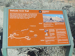
The Delicate Arch Trail
Mindful of the time, we have a quick Wendy's lunch stop in Moab. I want to ensure that we have enough time to make the hike up to the Arch before the sun sets. We arrive at the trailhead around 4pm and make ready to go. In the distance we can see loads and loads of hikers on the sloped slickrock leading up to the hike. Dad looks at this and feels a little discouraged. Tired from the previous hikes, he looks at what appears to be a formidable climb and is unsure about whether he can do it or not.

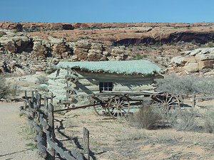
Wolffe Ranch
I recommend that we start off and see what we can do, and that we can always turn around if it gets too hard. The divide and conquer mental strategy is not to be underestimated! Also, Dad does not yet know the exquisite beauty that awaits at the end of the trail. He will not be disappointed if he manages it!
We start off with a quick side trip to the Wolfe ranch, an early "ranch" in this area before the park was formed (if you can call it that, since it is a only a one-room shack and a nearby lean-to).
Delicate Arch Trail terrain
The trail is wide and gravelled for the first bit, and we make pretty good progress. We make it to the base of the long slickrock climb and Dad is again uncertain. We coax him on and actually he finds it much easier than he had expected. We soon make it to the top of the slope and then along the final stretch around to an area near Delicate Arch, but hidden from it. One of the really neat things about Delicate Arch is that the trail approaches it such that it is totally hidden from view until the _very_ last seconds. I mean, one literally hikes to the very end of the trail, and it is only the last 10 feet where you get to see the arch suddenly appear before you, like a curtain being pulled from a beautiful picture.
We approach the final narrow bit of trail high up on a cliff and I make sure that we are all together as we reach the viewpoint at the end of the trail. I want to share this moment, because I know that it will be special. It always is for anyone I take on this trail.
Approaching Delicate Arch
Delicate Arch, a wonder of the world
We round the final corner and Delicate Arch appears in all its majestic glory. Sitting perfectly on the edge of a huge slickrock amphitheatre, with 12,000 foot snowy peaks gleaming white in the background, and the soft glow of the evening sun shining from behind us, I hear my Dad suddenly utter an exclamation of wonder and surprise. The Arch itself is incredible enough, slender, yet massive and very aesthetic in form. That, combined with the setting, makes this one of the most photographed scenes in the world. For good reason.
I have hiked to Delicate Arch at least 5 or 6 times in my life (so far!). Each time, I am always impressed by this place. It is a place to sit and contemplate one's place in the universe, to wonder at the sequence of events that have conspired to create a place of such beauty, totally unformed by the hand of man.
In summary, if you haven't been to see Delicate Arch and you one day find yourself somewhere within 500 miles of it, GO AND SEE IT!

courtesy George
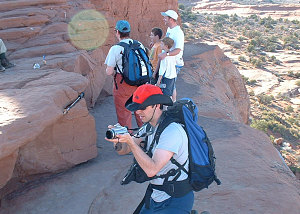
Andrew taking pictures at Delicate Arch
Dad and George at Delicate Arch
The interactive trackmap below shows the exact location and path of our Devil's Garden Loop Hike. You can even choose a topographic map overlay if you bring up the large version.
Interactive trackmap with photo points - Delicate Arch Hike - click map to view
Hike Data Display - Delicate Arch Hike
Start Time:
3:34p.m.
End Time:
6:18p.m.
Duration:
2h44m
Distance:
5.25 km
(3.26 mi)
Average Speed:
1.9 km/hr
(1.2 mph)
Start Elevation:
4205ft
(1282m)
*
Max Elevation:
5201ft
(1585m)
*
Min Elevation:
4104ft
(1251m)
*
End Elevation:
5170ft
(1576m)
*
* : +/- 75 feet
Total Elevation Gain:
1004ft
(306m)
*
Total Elevation Loss:
517ft
(158m)
*
* : +/- 75 feet
Elevation Graph
After soaking in the scene for a bit, we headed back down to the trailhead. As a final wrap-up to Arches, I wanted to catch the evening talk by the Park Service in the outdoor amphitheatre at the campground. The night's topic was to be about what made Arches a unique place.
The amphitheatre was situated in the campground, nestled between spires of sandstone and framed from behind by Skyline Arch. A portable slide projector had been set up and as dusk fell a crowd gathered to listen to the park ranger. A very pleasant fellow with an excellent speaking voice, he launched into a very interesting and at times eloquant presentation on the flora, fauna, and geologic history that made Arches such an interesting and unique place. Below are a series of links containing basically all of the ranger's talk, encoded in RealAudio and available for listening. I especially love the Ranger's quote of Edward Abbey at the end of his talk.
I think I can say with confidence that overall, we had had a much more in-depth and well-rounded visit to Arches than 99% of all of the park's visitors.
Well, another full day was done, and it was time to hit the sleeping bags again. Unfortunately there was one girl in a nearby campsite that had this very loud laugh. And she continued doing so for what seemed forever....