Firewarden's Trail on Mount Abraham - Trailhead Access Instructions
The trailhead is notorious for being not easy to find, so, in the spirit of providing good instructions (as others have already done on the web), here are mine. I recommend you either turn on the map pane when looking at pictures, or use the interactive trackmap at the end of this report - either will provide good context when interpreting these instructions.
Note: If you are looking for my Mount Abraham trip report, this isn't it. Please
click here to go to that report.
Update - September 15th, 2011: Hurricane Irene reportedly has damaged Rapid Stream Road and is currently impassable. It is unclear to me at this time how far you can drive up the road. You may need to hike a fair distance up the road and you may also need to ford Rapid Stream itself, should the bridges also be impassable.
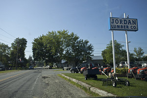
Hwy 27 and West Kingfield Rd
At the town of Kingfield, along highway 27, turn west onto West Kingfield Road. This road is paved. There's a decent view of the summit of Abraham not long after starting out along this road.
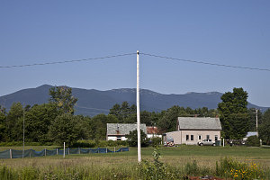
Mt Abraham from afar
After travelling along West Kingfield Road for about 3.3 miles (5.58 km), the pavement ends, and you come to a four-way intersection. You want to keep going straight. The road changes names, becoming Rapid Stream Road.
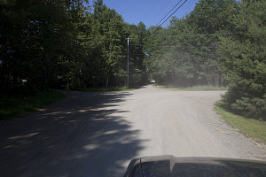
Start of Rapid Stream Rd
Rapid Stream road is gravelled, narrower and bumpy, but any vehicle can reasonably make it, so long as the driver is careful. The road leads north-west and gradually gains elevation, roughly following the east bank of Rapid Brook.
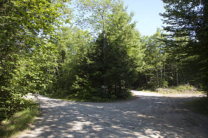
Take a left here
At about 2.4 miles (3.8km) after the start of Rapid Stream Road (or 5.7 miles/9.55 km from highway 27), you arrive at another junction. You want to turn left here (onto a forest road).
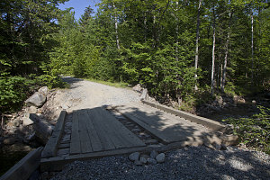
Bridge 1
Less than a hundred yards after turning left off of rapid stream road, you will come to the first of two bridges that cross Rapid Stream. The far-side footing of the first bridge has shifted and collapsed somewhat, causing that end of the bridge to have sunk. The bridge itself is still sound, however there is now a short step that your vehicle must surmount. If you have a low clearance vehicle your front bumper may dig into the ground or (especially if you have a low _and_ long wheelbase vehicle) you may bottom out. If you need to, you can park before this bridge and walk the final 3/4 of a mile (1-ish km) to the trailhead.
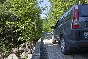
Bridge 2
Another couple of hundred feet brings you to the second bridge crossing of Rapid Stream. This bridge is sound and offers no difficulties.
Immediately after crossing the second bridge, the gravel forest road turns right. There is a faint, overgrown road leading straight ahead, but I think it is fairly clear that the way to go is to the right. The road, now with coarser gravel, climbs up a gradual hill for about half a mile (0.9km) and stops at a t-junction. Directly across the t-junction, you will see the Mt Abraham trailhead sign. Turn right and immediately after crossing a small bridge you'll see a grassy parking area on the right.
Total distance from highway 27 to trailhead: 6.4 miles (10.6km).
I don't know how if, how far, or how well this access route is maintained in winter. If I had to guess, I'd say that Rapid Stream Road doesn't get plowed.
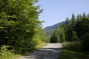
If you wish to drive further
Note: if you wish, you can drive further up the road (past the parking lot) to a higher access point on the firewarden's trail. Continue driving about 1.4 miles (2.3 km) until you reach a junction, where you will keep left. A further half-mile (0.6 km) will bring you to where the firewarden's trail crosses the road (distances approximate, as I have not personally driven this section of road). I also don't personally know if this road has any sections requiring 4wd or high clearance. Starting from this higher access point cuts off about 1.2 miles (2km) of trail (one way).
Interactive Trackmap - driving instructions to firewarden trailhead - click map to expand
Firewarden's Trailhead Access from Hwy 27 - Drive Data
Start Time:
8:48a.m.
End Time:
9:18a.m.
Duration:
0h29m
Distance:
10.72 km
(6.66 mi)
Average Speed:
22.2 km/hr
(13.8 mph)
Start Elevation:
371ft
(113m)
*
Max Elevation:
1089ft
(332m)
*
Min Elevation:
371ft
(113m)
*
End Elevation:
1084ft
(330m)
*
* : +/- 75 feet
Total Elevation Gain:
654ft
(199m)
*
Total Elevation Loss:
0ft
(0m)
*
* : +/- 75 feet
Elevation Graph
