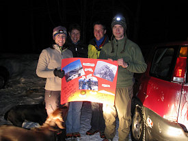
Knowing there was a good chance people were waiting for us at the parking lot, we didn't stay long and headed out. Night had now fallen, and we donned our headlights. Phuong's knee seemed a little better, and we managed excellent time on the stretch back to the parking lot, arriving back at 7:30pm. Quite a day!
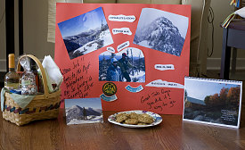
But not quite over yet! Mark and Linda had left a note that they had gone for gas and would be back shortly, and sure enough, after a few minutes, they roared up in their Subaru and popped out with arms wide open. Their congratulations extended beyond mere hugs, however: they had made up the most amazing set of gifts: a huge commemorative poster, our own winter 46r badges, a container full of fresh fruit, a plate full of fresh cookies, two bottles of wine, a bottle of champagne, a full gift basket of goodies, and a congratulations card. And, to top it off, they had waited for us in the parking lot for FIVE hours. We were beside ourselves.

courtesy PTruong
The real celebration
We had a delightful champagne toast by car headlights, and chatted until we were too cold. Mark and Linda, you really outdid yourself, and we want to again thank you for generosity that by all accounts was way beyond what we expected! What a wonderful way to finish off a very fulfilling day.
Signing off for now....
...Andrew

Just look at all this!
Interactive Trackmap & Photo Points - Haystack - Click map to expand
Haystack Hike Data Display
Start Time:
6:38a.m.
End Time:
7:31p.m.
Duration:
12h53m
Distance:
27.97 km
(17.38 mi)
Average Speed:
2.2 km/hr
(1.3 mph)
Start Elevation:
1541ft
(470m)
*
Max Elevation:
4993ft
(1522m)
*
Min Elevation:
1500ft
(457m)
*
End Elevation:
1500ft
(457m)
*
* : +/- 75 feet
Total Elevation Gain:
4216ft
(1285m)
*
Total Elevation Loss:
4251ft
(1296m)
*
* : +/- 75 feet
Elevation Graph
Regarding the above track and elevation data. Please keep in mind that my GPS shut off a few times due to excessive bouncing around (my clip broke), and there are a couple of spots where I've approximated the track. Also, there was extra walking to head back up to the summit with Ewart. So, please keep in mind that the distance data above may be off slightly (by 0.5 mile / 0.8 km, at most).
