Bridge Mountain Arch Route
Sunday, March 26
The last day of our Intercanyonnect trip - Sunday, March 26. The stars shone clearly in the sky as we got up before dawn. We finished preparing our gear and headed down to breakfast right at the 6am opening time. We were on a tight mission schedule today to complete the Bridge Mountain Arch route - a longer off-trail escursion to visit a long and delicate sliver of an arch near Bridge Mountain, overlooking Springdale and Zion canyon. Although the arch looked down upon a very civilized portion of the park, the route to get to it was circuitous and not obvious - we'd be in Zion's true backcountry for much of the journey.
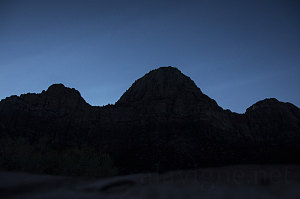
Bridge Mountain Silhouette
It was important for us to get started early and move fairly quickly. Our flight back to Canada left late in the evening back in Las Vegas, and working back from that, we calculated that we had to be back at the car by somewhere in the vicinity of 4pm, certainly no later than 5pm. Complicating matters was the fact that I had lost my wallet at the New York New York hotel in Las Vegas three days before (fortunately someone had found it and returned it to security), and we needed to allocate a somewhat indeterminate amount of time to fetch it on the way back.
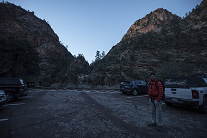
Clear Creek parking area
We made it to the start point of the route - at the top end of the Zion-Mt Carmel tunnel, at 7 a.m. Twilight was already brightening the landscape, so we were able to start off without headlamps. From the parking lot, we clambered down to and crossed Clear Creek, which had already stopped flowing after yesterday's heavy rains (which was a good sign for us).
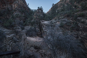
Crossing Clear Creek
After crossing Clear Creek, we needed to get into the valley of Gifford Canyon. There's a dryfall where it meets Clear Creek, but just to the left, there's an easily scramblable cimb up a treed slope that gave us access up and around the dryfall. Soon we were standing on the sandy floor of Gifford Canyon, ready to start our journey.
Unlike the messy floor of Spring Hollow from the day before, the floor of Gifford Canyon was a pleasant and mostly open wash of clean, orange sand. A small stream of water from yesterday's rains still played across the surface of the sand. Progress was good - except when there was a sudden patch of quicksand (perhaps only a foot or two deep, but still something we wanted to avoid). These patches of quicksand were hard to spot - one moment you were walking along on firm sand, the next moment you were sinking into the goop. After a short while, we started taking to climbing up onto the banks of the wash to make progress. Unfortunately, this exposed us to scratchy branches and brambles from the yet -unbudded vegetation.
After about fifty minutes of travel from the car, I determined that we had arrived at the point where we needed to climb out of Gifford. We needed to scale the southern slopes of the Canyon, climbing up to a saddle that would allow us to cross over into the next drainage system to the south. The terrain was fairly steep slickrock, dotted here and there with vegetation. It was not too steep to prevent travel, but steep enough to require a fair bit of concentration - especially since the temperatures were around freezing and some of the slickrock had frosted, slippery moss and lichens on it.
Careful routefinding and a few false starts saw us successfully complete the climb of the steep slickrock, locate a blocky, brushy chute past a cliffy section, and walk across a broad upper bowl of slickrock to the sandy saddle. Whew, I thought - that had been a lot trickier than I had expected. Although I had pored over the various descriptions of the route and had a clear topo map with significant points marked along the way, along with a fairly detailed text description, this was turning out to be trickier, harder [than expected].
The high saddle between the drainage of Gifford Canyon and the next drainage to the south was broad, flat and sandy. A good, relaxing place to stop for a morning snack break, and to survey the next part of the journey - the descent down an unnamed drainage known as the "east-west" canyon. A quick visual glance revealed nothing especially noteworthy (other than lots of beautiful slickrock), but the route description warned all was not as it appeared. Hidden dropoffs and dryfalls prevented a straightforward descent down the drainage's floor, and instead described a complicated route up and down and across steep terrain.
As it turned out, this description was entirely true. The descent into the upper part of the canyon was easy enough, but on the other side, we had to carefully find our way up and around several large hoodoos by way of a fairly exposed slickrock scramble. On the other side, we were presented with a steeply-sloping gully that - fortunately - had many smaller irregularities and gullies within it that allowed us to wind around, finding the least steep way down. It was all a fairly challenging puzzle, and we were glad to finally make it down to the bottom of this unnamed drainage.
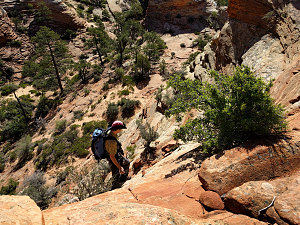
courtesy AHyndman
Scrambling over to east-west descent
Finding the easiest slopes
A short bit of slot brought us thankfully to a stretch of easy wide canyon floor walking, which soon led us down to a confluence with Hepworth Wash, the next major north-south drainage. Here we turned north, enjoying the pastoral beauty of this wide, well-vegetated valley. Unfortunately, the often sand-covered floor of the wash suffered the same problem as Gifford - patches of quicksand - so once again we were forced to bushwhack along the sides, getting more scratched up. Again during normally dry times, the sandy floor of the wash is probably perfectly acceptable to walk along.
lots of filled-in terrain
An easy twenty or so minutes down Hepworth Wash and we began to see, on the left-hand skyline, the outline of the back of Bridge Mountain. To its right was a lower section of slickrock cliff with several steep clefts cut into it. The center of these clefts (see picture) is the one we needed to angle for. We took a general line through the semi-open terrain of pines, junipers, and desert scrub towards it.
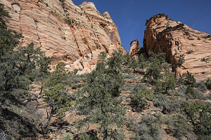
Looking up to narrow cleft
The cleft became more obvious are we neared it (also it became obvious that the other two clefts, left and right, were not climbable). We saw the occasional boot mark that let us know we were on the right track, and after a bit of steep hiking, we were at the top of the cleft. It immediately dropped back down steeply on the other side.
After all of that remote backcountry hiking to get here, we now (ironically) had a view down into busy Zion Canyon. It wouldn't be too long, we hoped, before we reached Bridge Mountain Arch.
Steep descent down other side
First, though, we had several obstacles to surmount. The first was a descent down the northern side of the cleft. It was steeper and brushier than the southern side, and there were several awkward little downclimbs to perform (although none with any exposure). Eventually the walls of the cleft began to widen, and here - instead of continuing down the steep grade - our route instructions told us to stay on the level, hugging the left-hand wall as it curved outward.
We soon came to a steep side-sloping bit of slickrock. It looked like it was angled just enough to hold foot traction, but there was a bit of exposure and one didn't want to slip here. Arn requested a belay for this section, so we took out our rope and belayed ourselves across.
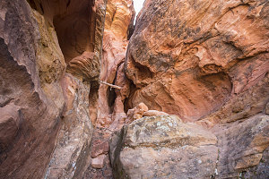
Vertical Chimney
On the other side of the short slab, a bit of easy scrambling brought us around a rib and back into another much smaller cleft. This cleft was vertical, and had an old log jammed across it about six feet up. Above that a series of chimneys, cracks and joints led vertically upward. It wasn't immediately obvious which one was the way up, but after looking at it for a while it seemed like the rightmost chimney (the one furthest to the west) was the actual climbing route.
Climbing route was indeed the correct word, for this was a more serious-looking climb that I had interpreted from the description. I couldn't see the top, and it was definitely of a low-to-mid 5 grade on the YDS scale - perhaps a 5.5 or so.
Looking at the climb, we realized that our stretch of rope might not be long enough for a safe rappel on the way back down. I couldn't be sure, but that was not a good feeling. We hummed and hawed for a bit, uncertain of what to do.