Summit day arrives - you guessed it - calm and clear. We quickly get up and start our preparations. In the middle of the night some climbers have already gone past us, up to the summit. We are all feeling tired and cold, and Markus hasn't slept well at all. We make a bit of warm drink and soup, wolf down some bagels, and have a bit of cheese. I spend a good hour and a bit making water by melting snow - we all know that it is important not to allow ourselves to get dehydrated.
Climbing the pumice ridge
Markus, ready for roped travel.
By the time we are all packed for the summit, and we've collapsed the tents to ensure that they won't blow away while we are gone, we are ready to go. The first part of the climb from our campsite is on a low pumice ridge, so we don't rope up or put crampons on. Several parties have come up and are mixed in among us at this point, and we let them go by.
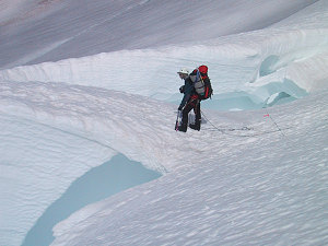
At the top of the pumice ridge is the last obstacle. A steep, hard, and crusty snow slope (part of the head of the Emmons Glacier) leads directly up to the summit plateau. We don our crampons and rope up - we have a bit of a scare as Peter's crampons keep slipping off, but Markus wades in and figures out how to properly configure the crampon's straps, and we are ok. Moving carefully on the steep terrain, we slowly but surely make our way up - and at this point the cat is practically in the bag; I think everybody realizes that their reservations were for naught, and everyone is going to make it!
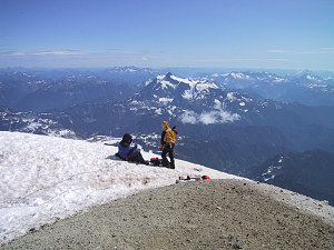
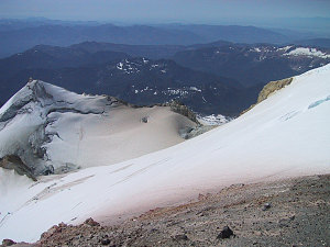
We crest onto the broad summit ice dome and make our way across it to the 'true' summit, a small bit of gravelly pumice sticking out at the edge of the dome. 10785 feet. Success! Ahead the cragginess of the North Cascades is fully revealed, with mighty Mount Shuksan only kilometres away. To our left is the deep summit crater, where we can clearly see several volcanic vents with gasses issuing forth. And to the west is.... what is this? it looks like a front of clouds, about at our altitude, heading our way.... hmmm.

courtesy MWandel

courtesy MWandel
View across to Mount Shuksan
The air is chilly up here. Probably not much above freezing. Markus is cold. And hungry. Everybody else has left the summit. As we send a quick e-mail and I call my dad using Peter's cellphone, this line of clouds reaches us, and with a big increase in wind. Bits of cloud whip past, occasionally obscuring our view. It is like being up in an airplane, except that you are outside sitting on the wing! Not being sure if the weather is really changing into something nasty or whether this is just a passing phenomenon, I make noises about getting off of the summit quickly. After a bit of hasty thrashing about, we scurry off the summit and back across the summit dome to our descent route. All sorts of weird cloud formations whip by, presumably a result of the clouds and air being forced up as they reach the summit area of Baker.
It is not long before we reach the steep area and carefully crampon back down to the top of the pumice ridge. We get below the level of the clouds and the wind, although by now it is becoming apparent that there is no major weather change, and things still look good. The wind eventually disappears altogether, and the clear sunny day returns with a few puffy clouds mixed in.

courtesy MWandel
Down the climber's trail.
We arrive back at our 9000 foot campsite shortly after noon, and decide that we are feeling grimy, tired, sweaty and, to quote Markus "hungry for a good cheeseburger and a shower". So we efficiently pack up our camp and skeddadle our way back down. The dicey snowbridges are still there and they still hold, and our group is getting more comfortable stepping downhill rapidly on snow, and the kilometres pass quickly. It is not long before we are at the base of the glacier, on a now warm, beautiful, sunny day. We shed all of our "clanky bits", as Markus calls them, and set off down the climber's trail. Apart from one somewhat unfortunate stream crossing incident, we all make it back safe and sound late in the afternoon. Handshakes are exchanged all around.
Interactive trackmap with photo points - Day 3 - Summit and Descent - click map to view
Climb Data - Mt Baker Summit Day
Start Time:
7:05a.m.
End Time:
6:02p.m.
Duration:
10h56m
Distance:
11.48 km
(7.13 mi)
Average Speed:
1.0 km/hr
(0.7 mph)
Start Elevation:
9059ft
(2761m)
*
Max Elevation:
10815ft
(3297m)
*
Min Elevation:
3847ft
(1172m)
*
End Elevation:
3856ft
(1175m)
*
* : +/- 75 feet
Total Elevation Gain:
1788ft
(545m)
*
Total Elevation Loss:
6945ft
(2117m)
*
* : +/- 75 feet
Elevation Graph
Day 3 - Elevation over Distance
Day 3 - Elevation over Time