courtesy JInnes

courtesy JInnes
Recording the Awesomeness
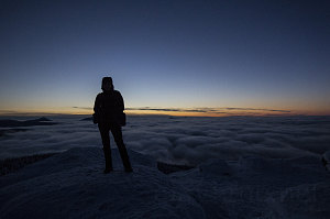
As magical as our twilit summit was, we soon began to feel the bite of the cold. We took a final round of pictures and then made ready to head down, getting out our headlamps to prepare for the dark walk back down to the trailhead.
Shining small pools of light down onto the snow in front of us, we picked our way back down the open terrain to the edge of the trees. It was immediately cozier and warmer in the forest, and it wasn't too long before a zipper was undone or a hat came off.
Our walk back down was easy and unrushed - the only annoyance being perhaps the somewhat bouldery Cascade Mountain trail. We arrived back at the cars shorly after 6pm. It was still quite early, even though it felt late. The early darkness of December is misleading.
I could not have picked a better outcome for this, our second twilight hike. Where the first hike had demonstrated the beauty of post-sunset light reflecting off of high-altitude clouds, today we had the opposite: super low clouds and a clear sky above. It was a wonderful contrast and further demonstrated the extreme beauty these unconventionally-timed hikes can provide. Thanks to everyone who joined today, especially for their perserverance on the admittedly fast pace we set to ensure arrival at the views before sunset. I hope you can all make it to the next one! Hopefully we'll get to try out a morning outing.
Interactive trackmap with photo points - Cascade Mountain - click map to view
Cascade Mountain - Hike Data
Start Time:
2:56p.m.
End Time:
6:20p.m.
Duration:
3h23m
Distance:
7.06 km
(4.38 mi)
Average Speed:
2.1 km/hr
(1.3 mph)
Start Elevation:
2201ft
(671m)
*
Max Elevation:
4119ft
(1255m)
*
Min Elevation:
2133ft
(650m)
*
End Elevation:
2160ft
(658m)
*
* : +/- 75 feet
Total Elevation Gain:
1919ft
(585m)
*
Total Elevation Loss:
1964ft
(599m)
*
* : +/- 75 feet
Elevation Graph
