Outing #3 - Baxter Mountain
We had ticked off two short hikes pretty quickly, all in all. It was still morning, only shortly after 11 a.m., and we still had nearly three hours before the predicted start of rain. It looked like we just might be able to achieve our 3-hike no-rain objective. That final objective, the start of which we now stood before, was Baxter Mountain - a modest peak tucked into the crook between highway 9N and route 73. The sign indicated a 1.1 mile distance and 700-foot gain - neither of which seemed too daunting.
Unlike our previous two hikes, there were a lot of cars parked on the side of the road near the trailhead, and we encountered several other hikers on the trail as soon as we started out. It was also clear that this was the most travelled of our three routes so far today, with a wide and well-beaten track leading up through the woods.
The first part of the hike up Baxter was extremely straightforward, easy hiking. Unlike many Adirondack trails, this section had a well-engineered switchbacking section, which made the hiking even easier.

courtesy JInnes
The well-engineered, switchbacked trail led up to a small forested saddle on the eastern shoulder of Baxter Mountain. A side trail leads down from here towards Beede Road in Keene Valley. We turned right instead, following the much more beaten-down path leading up towards Baxter.
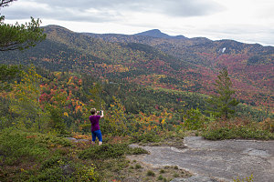
The trail got much steeper here, and somewhat rough in spots, but nothing atypical for the Adirondacks. The first good lookout points soon came into view, all facing south towards the Hopkins / Giant Mountain area. More excellent fall-colored hillsides in full view, too.
Already we were nearing Baxter's summit elevation, and the trail's grade started to ease. We alternated between pleasant forest track and scenic ledges. The summit area itself is composed of two heights of land, and it seemed that most people stopped at the first, lower bump. We continued on, descending slightly on a more primitive path, and then back up to the higher bump.

courtesy JInnes
Although the true summit had less views, it was still a pretty nice spot. The trail led through a sublime bit of open forest meadow - a rarity for the Adirondacks. The trail continued down the western flanks of Baxter Mountain, destined eventually to arrive down in Keene Valley. Today, however, we stopped here. I'd like to hike the full length some day.
Just off from the summit was a decent viewpoint where we had a quick snack and rest break, and prepared to turn around. Looking out over the landscape, it still seemed like the rain was not imminent. It was now fairly clear that our rain-avoidance strategy was going to work.
The winds became more gusty as we made our way back along the easy trail to Baxter's route 9N trailhead, arriving just before 1pm. We'd indeed managed to get an excellent sampling of the fiesta of colors from three different and worthwhile little Adirondack hikes - Hikes that I'll definitely be adding to my 'good short hikes' shortlist.
As a final note, it did indeed start to rain as we were driving back home, and right around the forecasted 2pm start time. And it soon became a downpour.
Interactive trackmap with photo points - Baxter Peak - click map to view
Start Time:
11:21a.m.
End Time:
12:49p.m.
Duration:
1h28m
Distance:
4.07 km
(2.53 mi)
Average Speed:
2.8 km/hr
(1.7 mph)
Start Elevation:
1662ft
(506m)
*
Max Elevation:
2376ft
(724m)
*
Min Elevation:
1650ft
(503m)
*
End Elevation:
1651ft
(503m)
*
* : +/- 75 feet
Total Elevation Gain:
674ft
(205m)
*
Total Elevation Loss:
698ft
(213m)
*
* : +/- 75 feet
Elevation Graph