This was a last-minute outing, put together after various impediments prevented us from hiking for too many weeks. Jenn was feeling the need for a non-Adirondack hike; Chris and Gillian, who had expressed an interest in joining, had some time limitations. Putting those constraints into the mysterious trip-picking machine - along with the requirement of something scenic and maybe something new for the ol' Lavigne-man, out came a hike on Mount Mansfield, in Vermont. Not in the Adirondacks, but still not too far of a drive, definitely scenic, and still containing some unexplored bits.

Underhill State Park
Our trip day fell on the Canadian Victoria day holiday - Monday, May 23. In order to fit with Chris and Gillian's time constraints, we elected to leave on Sunday evening and stay overnight at the Underhill State Park campground, located directly underneath Mt Mansfield, in the big forested bowl immediately to the west. Although technically still pre-season, we determined that it would be ok to stay in the campground, but without facilities and with a short walk from the closed gate.

Late-night arrival
Arriving after nightfall, we parked at the closed gate and hoofed our way up in the dark to the first of the campsites. The distance really isn't all that far - less than 400 metres / yards, and soon we had our tents set up and bedding laid down. Given the late hour, we quickly called it a night. The aim was for a reasonably early finish the next day, and that meant a very early start.
5:30 a.m. was the get-up time. At this time of year, it was already fully light. Chris made a hot breakfast while I packed up stuff. Given the closeness of the car, I had decided that I could take a few minutes to pack out all of our camping gear to the car before starting out on our hike.

courtesy JInnes

courtesy JInnes
We were ready to go by a very decent 6:40 a.m. Conveniently (and this is one of the things that makes Underhill SP a great place to base yourself when hiking Mansfield), we were basically already at the trailhead. All we had to do was start walking, uphill through Underhill State Park.
There is one main gravel access road in the park, and it switchbacks a few times as it ascends to the highest facilities in the park (which is a group campsite area and a building with weather equipment). Cutting across these switchbacks is a wide access trail called the Eagle Cutoff trail. Ten or fifteen minutes climbing upwards along this trail brought us to the start of the loop portion of our hike: the junction of the CCC road and the Sunset Ridge trail.
Our plan for the day was similar to the plan I had the last time (
just last year, in fact) I had hiked Mansfield: a traverse across Mansfield's ridge from south to north. Plenty of open terrain, beautiful views. Jenn, Chris and Gillian would surely enjoy it. And, I had planned a few variations for myself that would satisfy my desire for exploring something new.
The next section of our hike, travelling south along the CCC Road trail, was quite easy. A remnant of 1930s-era CCC work, the old road-turned-trail is a gentle and straightforward way to cross the big western bowl below Mansfield's summit ridge. It would bring us to the start of Maple Ridge, our ascent route up towards the southern end of Mt Mansfield.
We reached the lower end of the Maple Ridge trail shortly after 7:30 a.m. Instead of veering off onto the Teardrop winter ski trail (which is what I did on last year's winter hike), we actually stayed on the Maple Ridge trail. So, this was the beginning of new ground for me.
The lower part of the Maple Ridge trail is forested. The trail's tread was mostly bare and unbroken bedrock. It was steep, but quite grippy and secure, despite being wet. This section is probably a thick, steep ice sheet during melt-out in the spring.
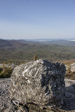
We were pleasantly surprised how, at the very modest elevation of 2850 feet, we arrived at an excellent open-slab viewpoint. Revealed to us was a hazy Champlain Valley, with a few far-off hollows filled with cottony-white early morning fog.
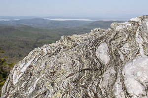
The lookout wasn't a one-off, either. The trail, now climbing up directly on the crest of Maple Ridge, crosses over many open patches and big rock ledges. In addition to providing great views and open hiking, interesting geology was on display, in the form of strikingly foliated schist bedrock.

courtesy JInnes
I was quite impressed with the Maple Ridge Trail. I hadn't realized that it offered this much open terrain, interesting ledges, and easy bits of scrambling. I suppose its reputation is overshadowed by the even-more-open Sunset Ridge to the north. Highly recommended.

courtesy JInnes

courtesy JInnes