This last steep and dark gully popped us out onto a small open clearing, partially covered in grass and with a nice open view to the east. We had arrived on the summit ridgeline of Snowy, and all of our steep climbing was now behind us.
It was mostly overcast, although a high overcast which didn't block any views. The view east provided a nice panorama of long and narrow Indian Lake in the foreground, and across a long stretch of gentle southern Adirondack Mountains in the distance.
After taking a short break and enjoying the eastern views from the grassy clearing, we began to explore the rest of the summit area. We immediately noticed that the grassy clearing had many well-defined little herdpaths radiating out from it. We chose the first on the right and began a methodical exploration.
The first little path brought us to an excellent little viewpoint near the northern tip of Snowy's summit mass. From here we could see the distant silhouette of the Central High Peaks. Returning back, we angled off on one another little herdpath. This led to an intersection with yet two more herdpaths, and we turned right and arrived at another excellent viewpoint, this one looking west.
Yet more herdpath options presented themselves as we moved on from the second lookout, and eventually we intersected the main official trail leading towards the firetower. This we followed uphill for a short distance to the base of the tower, which rose out of fairly thick forest cover on the southern end of the summit mass. It looked to be in quite good shape, silvery and not at all rusty-looking. A good quality set of steps led upwards to the observation deck.
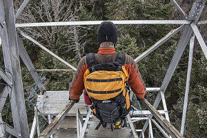
It grew airier and much cooler as we ascended up to the small observation deck, where a small articulated trap door allowed access. Where the air at the base of the tower had been calm, up here in the flow above the tree tops, a cold wind - not super strong, but very chilly - blew through the glassless frame of the observation deck. It was a wonderful view in all directions, but I took to crouching down below the level of the open windows in order to stay out of the moving air.

courtesy JInnes
The chilly conditions did not promote lingering at the top of the fire tower, and after a few pictures, we headed back down to have lunch at the tower's base.
We then began our descent (after putting on traction aids), first returning to the open clearing and then beginning the rough descent.
I had heard that the big slabby cliffs below Snowy's summit block were known among the
climbing community, and that a discernable footpath was available that led to the base of these cliffs. I noticed a bit of flagging not far below the summit clearning and I suspected that this was the marking for this footpath. Roland and I branched off for a few minutes to investigate.
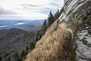
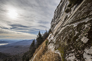
A few seconds after heading off onto the faint herdpath, we could see the steep slabs of the summit cliffs through the trees, the angle between us and the faintly shining sun making the wet streaks on the face glisten brightly. It was farther away than it looked - I had to follow the faint path quite a ways to the southwest, up and down some steeply-sloping terrain, until I reached the open edge of the cliffs. I was partway up, and a small grassy ledge - no more than 12-18 inches wide, led across the face at this point.

Snowy's big slabs
The slab was pretty big, both upwards and downwards from my current point. It looked like most of the climbs would be very slabby affairs - something I'm not particularly comfortable with. Adding to the difficulty at this moment would be the fact that there was a fair bit of wetness on much of the rock, and no doubt some of it was subtly frozen. I wasn't surprised that there weren't any climbers here today.

Big Slabs
I didn't have too much time to explore - Roland had already turned back and the others were waiting back at the official trail. I ventured only a short way out onto the ledge, which was airy but which could be walked if one took some care. One section had a few hangers bolted into the rock with a bit of climbing rope strung between them, acting as a safety handrail.
Turning back, I retraced my steps to the intersection with the official hiking trail, then started hiking down with Roland. The others had gone on, and it took some time before we caught up to them. A lively conversation about the nature of risk and how humans perceive it helped take our minds off of the eroded, wet, bouldery trail.
Once back down at the 2500-foot level, the grade once again became gentle (and the trail less rough), and we were able to pick up the pace. We stopped to take some long exposure photographs of some of the many stream crossings, but other than that, our march back was fairly quick and uneventful.
So, our trip up Snowy went quite well. The weather was fairly warm for late November, and the air clarity and views were good. The summit area has many attractive qualities: the nice bit of open meadow, the excellent north and west lookouts, and, of course, the nicely-preserved and climbable fire tower. The trail, though... less than attractive. It was wetter and much more eroded than I had expected. This would probably be better done as a winter hike when there is a nice 3+ foot snowpack covering everything. Maybe the motto should be... Climb Snowy when its snowy.
Interactive trackmap with photo points - Snowy Mountain - click map to view
Hike Data - Snowy Mountain
Start Time:
8:59a.m.
End Time:
2:59p.m.
Duration:
5h59m
Distance:
12.46 km
(7.74 mi)
Average Speed:
2.1 km/hr
(1.3 mph)
Start Elevation:
1846ft
(563m)
*
Max Elevation:
4006ft
(1221m)
*
Min Elevation:
1828ft
(557m)
*
End Elevation:
1830ft
(558m)
*
* : +/- 75 feet
Total Elevation Gain:
2225ft
(678m)
*
Total Elevation Loss:
2243ft
(684m)
*
* : +/- 75 feet
Elevation Graph