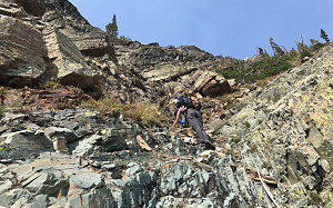
Doug showed skill on the steep terrain. Always slow and steady, he had a quiet demeanor and steady, analyzing gaze. Frequently he would explore one avenue of ascent while I explored another, and we'd rejoin a little higher up, agreeing on the best of what we'd found. I had been impressed when I had taken my then-83-year-old father on some fairly long trail hikes in Southern Utah some time back, but this surpassed that feat handily. He was basically the same age, but he was sure-footedly scrambling with us on semi-technical terrain. That's no small feat.

courtesy GBrancatelli
We made pretty good and fairly quick progress up the gully network we'd chosen, and soon we could crane our heads up and see what looked like an approaching lip, a line where the terrain seemed to ease off. Sure enough, it did, and we crested into a sloping drainage mostly composed of reddish argillite scree.
Gino Climbs to Grander Views
It soon became apparent that there were no further difficulties ahead of us: a low-angled open slope (maybe 15 degrees at most) of broken scree and small boulders lay between us and the highpoint. Gino relaxed visibly at the easier terrain. We also began to see a few other hikers, some with dogs. We had not seen these people on the climb up, and the fact that they had dogs with them implied that there was some easier route to get up here - one not mentioned by my scrambling guide. Gino noted these facts with interest.
Yeah... and then I had to hold on like this...
After a nice long break on the lower part of this gently-sloping plain, we began our plod to the top. It was not difficult, just a bit tiring (especially owing to the fact that we were now nearly at 8,000 feet and we had not yet acclimatized to the higher altitude out here). The hike up this section reminded me a lot of the alpine hiking in the upper reaches of the Presidential Mountains of New Hampshire, back out east. Rough, angular boulders spread out over relatively gentle terrain, and a bit of krummholz or alpine grass sprinkled here and there.
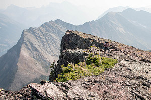
The sense of out-eastness soon dissipated as we came upon the crest of Bertha Peak's east face. The precipitous drop was a bit dizzying and unfamiliar to anyone used to gentle eastern mountains. It also, however, provided fantastic views down into the valley of Bertha Creek (which we had hiked up not that long before) and to Upper Waterton Lake itself.

Precipitous Crest
After reaching the crest of the east face, we followed along it to the highpoint itself, which wasn't that many more minutes away. We had arrived on top at about 3:30 pm, which was -- all things considered -- pretty decent considering our start time of 10:30 a.m.
We shared the summit with the other hikers we had spotted earlier. As it turns out, one of them was a descendent (grandson or nephew, can't recall exactly) of the very Bertha Ekelund after which this peak was named. A very interesting and curious coincidence for us to summit at the very same moment as that of a descendant of a peak's namesake. I don't believe that has ever happened to me before.
The summit is right on edge of the east face, and fairly close to the north face, and although the western approach slope is broad and wide, the big dropoffs to the east and north give the summit a bit of an airy feel. That, combined with the fairly gusty wind up here at the summit, was enough to induce an occasional bit of the willies in Gino and Julian. They stayed low and carefully distanced from the edge.
A bit of a further comment on the scenery: it was wonderful, of course, with jagged mountains to the south and west and the tawny prairies stretching away to the east. But there was something else - a lot of haze. Smoky haze. We had noticed it gradually increasing as we had climbed, but now that we were fully stopped and scenery-gazing more closely, we could definitely tell it had gotten a lot thicker. This, we presumed, was an effect of the huge 2020 wildfires burning up and down much of the American west coast. It had finally wafted its way up into Canada. It gave everything a dull pallor, and especially to the south, we really couldn't see all that far.

courtesy GBrancatelli
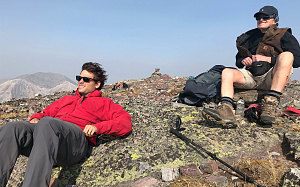
Julian, Doug, Bertha Summit
After an enjoyable stop at the summit, taking in the views and talking with Bertha Ekelund's relative, we began our descent of Bertha Peak. We decided that we were going to follow the likely route that these other summiters used, and we had a fairly good idea of where that route went.
Down at the base of the broad, sloping west summit slopes, there was a small little strip of meadow with tall grass. From our higher vantage point, we could easily see a footpath trampled in this tall grass. It disappeared into a little hump of forested terrain. It was so distinct and well-formed that it seemed unlikely to be anything other than a well-used ascent/descent route. And therefore likely the easiest way down. Gino had already hurried down ahead of myself, Julian and Doug. He definitely wanted that route to "go".
Sure enough, once down in the little meadow, a clear footpath led into the forest. The path led uphill briefly, then across the top of a small knoll. The knoll was treed with fairly big trees, and it formed a neat kind of forest-island, surrounded by open alpine. Soon the path started descending again and we emerged onto the south-facing flank of Bertha Peak, but this time a little bit farther to the west.
Bertha's Summit Ridgeline
Continuing Easy Descent Route
The little footpath steepened, quite a lot, and started to braid and split as it entered an area of steep gravel and a bit of scree. We could see all the way down to Bertha Lake now, and it was obvious that this was indeed much easier. Although steep, there wasn't any actual scrambling, and with careful foot placement, it was only a steep hiking descent. This was clearly the way the hikers with the dogs had come.
Stepping carefully and gingerly, we hiked down the steep open slope, getting comfortable with the little foot slips and slides that inevitably happen on such terrain. Poles were a big help on this stuff, providing that extra bit of support should your foot slip a little too far.
We lost the main footpath in all of the little braids and divisions on the slope, and by the time we got down to treeline, it was nowhere to be found. Since we weren't too far from the lakeshore and the Bertha Lake trail, we decided to just bushwhack straight down through the (admittedly fairly bushy) forest, and in a few minutes, we intersected the trail around the lake. We turned left, heading back down-valley towards the lower end of the lake. Along the way, we noticed a small cairn and distinct little footpath that marked the proper lower end of the footpath we had been following (but then lost) from above. I took a picture here in case anyone wants to know what the start of this easy hike-only ascent route of Bertha Peak looks like.
From here our route-finding was over. We quickly hiked back to our earlier lakeside lunch spot and had another final rest break - then started off on the descent back down the official trail, down the valley towards Upper Waterton Lake.
The onset of smoky, hazy sky we had observed on the summit had worsened. Even the big mountains right on the other side of Upper Waterton Lake, like Vimy Peak, looked pretty hazy. The air smelled faintly of "campfire".
Final look at ascent cliffs
On the wide, flat, well-engineered path, we made quick time of the return to the trailhead, descending from Bertha Lake back to the townsite in about 90 minutes. Here we thanked Doug (McLean) for his great companionship, and we learned that he was in the RV section of the townsite campground not too far away from us. We promised to stop by later, after we had organized ourselves at our tents.
Arriving Waterton Townsite Campsite
Interactive trackmap with photo points - Bertha Peak - click map to view
Scramble up Bertha Peak - Climb Data
Start Time:
10:22a.m.
End Time:
7:45p.m.
Duration:
9h22m
Distance:
16.59 km
(10.31 mi)
Average Speed:
1.8 km/hr
(1.1 mph)
Start Elevation:
4222ft
(1287m)
*
Max Elevation:
8029ft
(2447m)
*
Min Elevation:
4209ft
(1283m)
*
End Elevation:
4209ft
(1283m)
*
* : +/- 75 feet
Total Elevation Gain:
3923ft
(1196m)
*
Total Elevation Loss:
3931ft
(1198m)
*
* : +/- 75 feet
Elevation Graph

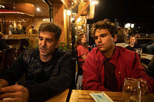
Evening wrap-up at the Thirsty Bear
It had been a pretty whirlwind day - driving down from Calgary, snagging a first-come/first-serve tentsite in Waterton, grabbing a few quick day-hiking snacks from a corner store, getting on the trail by 10:30 a.m., doing a fairly stiff 17km / 4,000 foot elevation climb including a scrambling section, and making it back down to the parking lot before sunset. As dusk set over the campground, we had not yet managed to locate and acquire a propane/butane canister for our camp stove - and we didn't really feel in the mood for dehydrated food by headlamp anyway. Since Waterton National Park's townsite has a legitimate (but small) little main drag, with shops and restaurants, our cooking problem was solved. We wandered around the two-block downtown and came upon the Thirsty Bear Kitchen & Bar. Fish Tacos for me, a burger for Gino, and keto wings and salad for Julian.