Lower Calf Creek Falls
Saturday, April 20
Today was a sort of slush day between the two main backpacks of our trip. We wanted something interesting, but not particularly long or hard.
First, though, we absolutely did not want a repeat of yesterday's botched attempt at getting a campsite. Especially since we were still smack in the middle of the Easter long weekend. So, immediately after departing the Prospector Inn, we made a beeline for the State Park campground, and we consulted the hosts at the gate as to which guests were about to depart their sites. Soon afterwards, we had our reservation tag on a very nice soon-to-be vacated site and shortly after that, we were unloading our gear and setting up our tents. No aimless campsite wanderings for tonight!
With the campsite situation sorted out, we turned our attention to the day's activities. So, a "slush" day... filler... those words make it sound like we wanted something wasteful, but no - just straightforward logistics and not too hard or long. There aren't many such outings in the Escalante, so maybe that is why the parking lot and trailhead for our chosen hike -- to Lower Calf Creek Falls -- was jam-packed with cars and people. And the fact that it was Easter Saturday.
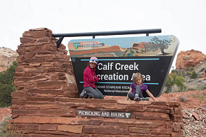
Lower Calf Creek Hike
The Lower Calf Creek Falls Trail -- and the adjacent Lower Calf Creek Campground -- are right off of Utah State highway 12 just to the east of the bridge over the Escalante River. As one of the few officially-maintained trails in the entire Grand Staircase-Escalante area, it gets a lot of use. And also because at the end of the trail is a very, very beautiful attraction: the slender ribbon of falling water known as Lower Calf Creek Falls.
We started off in a veritable crowd of hikers, but fortunately, since we were starting almost at noon, many of them were on their way out. After a few tens of minutes out on the trail, we had the trail somewhat to ourselves.
The Lower Calf Creek Falls Trail has a self-guided interpretive program, and we had picked up an interpretive pamphlet at the trailhead. The pamphlet had numbered sections that one can pair up with similarly-numbered posts along the trail, allowing you to match up the text with the right spot along the trail. Katie was soon promoted from mere hiker to interpretive guide, and was given the pamphlet.
Lower Calf Creek Falls Trail
As we walked up the canyon of Lower Calf Creek, we stopped at each interpretive post and got a reading from our new guide. It was cute, and it was kind of nice to have someone read it aloud to the group. We learned about the indigenous artifacts and structures in the canyon, local flora, fauna, and geologic information.
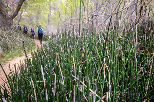
The Lower Calf Creek Falls trail is a 10km (6mi) there-and-back trail. At the trailhead, the canyon was wide (perhaps a few hundred yards wide) and the trail was bordered with fairly typical dry-tolerant desert plants. As we approached the falls, the canyon narrowed, deepened, and became lusher and more densely vegetated, now with primarily riparian vegetation - rushes, cottonwood trees, that sort of thing. And then, peeking through the branches and foliage, we spotted a delicate, high ribbon of water ahead.
Another Interpretive Stop
courtesy JInnes
Through Horsetail Thickets
Lower Calf Creek Falls drops into a large amphitheatre in the canyon of Lower Calf Creek. The Canyon continues on above the falls, of course, but this huge drop blocked any further travel upstream. Instead, we stopped and marveled at the elegant beauty of the falls - one main flow and a minor parallel one, both coming back together at the bottom into an almost perfectly round, wide pool. There was a nice sand beach surrounding the pond, and further back from that, a small forest of trees with fresh greenery.
courtesy JInnes
Lower Calf Creek Falls, Side View
Although there were a fair number of other hikers about, there was enough space for us to disperse and not feel too crowded. We stopped for a late lunch here, getting an occasional bit of cool spray off of the falls.
Our journey back was a bit faster, given the lack of interpretive stops, and we finished the whole hike in just over four hours. It's pretty and easy, well-marked and fairly accessible. Definitely a good hike for anyone wanting a curated, well-established, minimal-thinking-required sort of experience.
courtesy JInnes
Interactive trackmap with photo points - Lower Calf Creek Falls - click map to view
Lower Calf Creek Falls - Hike Data
Start Time:
11:29a.m.
End Time:
3:44p.m.
Duration:
4h15m
Distance:
9.4 km
(5.84 mi)
Average Speed:
2.2 km/hr
(1.4 mph)
Start Elevation:
5322ft
(1622m)
*
Max Elevation:
5478ft
(1670m)
*
Min Elevation:
5320ft
(1622m)
*
End Elevation:
5336ft
(1627m)
*
* : +/- 75 feet
Total Elevation Gain:
224ft
(68m)
*
Total Elevation Loss:
206ft
(63m)
*
* : +/- 75 feet
Elevation Graph
All right... so our "slush day" hike was done, and it was time to head back to our nice state park campground near Escalante. We decided to stop at the conveniently-located Kiva Koffeehouse, situated just after the crossing of the Escalante River on UT12. It's a beautifully-situated low-slung building, thoughtfully built into a high point overlooking the canyon of the Escalante. It's wide, round customer seating area looks out of a long, curved set of windows that gives a panoramic view down the Escalante drainage. The coffee and the treats to go with the coffee are both excellent. They are also quite rigid about their closing time - 4pm.... outchya go, chop-chop!
Petrified Forest Interpretive Loop
After picking up some groceries that we'd be using for dinner, we arrived back at our state park campsite shortly after 5pm. The day had transformed from somewhat drab high cloud to brilliant, crisp sun, and impressively, we were still in the mood for some physical activity. The Escalante Petrified forest state park had a short interpretive trail centered around petrified wood deposits, and everyone seemed keen to do it. Katie was keen to continue her role as trail guide interpreter, too!
Switchbacks above Campground
The trail started right from a very nice interpretive display area next to the campground, with big colorful panels discussing the nature of petrified wood and how there came to be such a rich deposit in the mesa behind the campground. There was also a very nice example of a full petrified tree trunk here, from root ball nearly to tip. cool.
The trail itself was fun, switchbacking up expertly towards the nearby mesa top. Very quickly we had a nice eagle-eyed view back down to all of the campsites. Along the way, Katie once again carefully and dutifully read out the various paragraphs associated with each interpretive signpost number.
Arriving at the good stuff
Once on the mesa top, the trail described a meandering loop through a dry open forest of short junipers and pines. There were a few really good embedded specimens, and other than that most of the petrified wood we encountered was scattered about in smaller chunks. Near the end of the loop section was one especially huge section of petrified tree trunk where the growth rings were exceptionally visible.
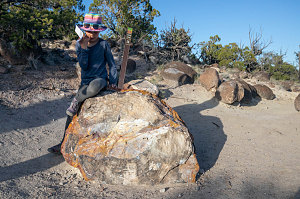
One of the biggest trunks
The whole hike was over pretty quickly - maybe an hour in total. Back at our campsite, Chris broke out a couple of packs of sausages he had purchased along with some old-style charcoal briquets, and we grilled up the whole lot of them for dinner.
We also chatted about our plans for the next few days of the trip. We were still all interested in a two-day traverse backpack, the one I had mentioned a few pages back and which started high up on the slopes of nearby Boulder Mountain. Despite the fact that we had encountered some snow near the upper trailhead, I felt that it was still something we could manage, and that our encounters with snow would probably only occur during the first part of the first day's segment of the backpack.
We discussed the specifics of the required logistics, and everyone was good with the plan. The next morning we'd depart bright and early from our campsite, ready to tackle this next challenge.
Interactive trackmap with photo points - Petrified Wood Loop - click map to view
Escalante Petrified Wood Loop - Hike Data
Start Time:
5:56p.m.
End Time:
7:13p.m.
Duration:
1h17m
Distance:
2.51 km
(1.56 mi)
Average Speed:
2.0 km/hr
(1.2 mph)
Start Elevation:
5960ft
(1817m)
*
Max Elevation:
6216ft
(1895m)
*
Min Elevation:
5948ft
(1813m)
*
End Elevation:
5961ft
(1817m)
*
* : +/- 75 feet
Total Elevation Gain:
270ft
(82m)
*
Total Elevation Loss:
257ft
(78m)
*
* : +/- 75 feet
Elevation Graph