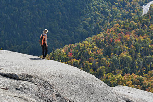
After lunch, we continued west along the ridgeline. Again the terrain isn't very challenging or rough here, just a nice route wandering through the higher-altitude coniferous forest typically found at the 3000-4000 foot elevation in New York state, frequently on solid bedrock and with nice patches of lichen or moss lining the path. And with the occasional lookout thrown in, mostly on the side looking out to Cascade Pass. We could see how we were slowly making progress towards the far end (the southwestern end) of the pass.
We reached the actual highpoint of Pitchoff Ridge along this bit, but there wasn't much to report, since it is essentially just a big boulder on a thickly-wooded bump. Instead we focused our thoughts on the great western lookout (as I like to call it). So, continuing on, we followed the trail as it lost about 450 feet of elevation, descending to a narrowing point that has extensive flat, open rock that drops off to the west. It was (and is) a great panorama, with the Lake Placid area visible to the northwest and the Central High Peaks visible to the southwest. And Cascade Mountain, directly across Cascade Pass from us.
Approaching Grand Lookout
The central attraction of the western lookout are two huge glacial erratics, perched not too far from the lookout's nose (the ridge narrows and then tapers down into the forest in a sort of prow or nose of rock). These two boulders are easily climbed, and we did that and took several great high-against-nature shots.
Mouhcine then noticed the great crack which splits the bedrock of the lookout's nose. It's really like a short slot canyon, twenty or so feet deep and maybe fifty or sixty feet long. Mouhcine and Theresa both scrambed down and around and into it, then came through it and climbed back up to us. With Mouhcine's exuberant nature, I knew he'd be up for some action shots, and I got him to leap across the great crack while Theresa climbed up out of it from below.
Theresa, Pitchoff Lookout

courtesy DKumar
Theresa, Pitchoff Lookout
After thoroughly taking in the great lookout, we backtracked slightly to the start of the descent trail to the western trailhead. This side of Pitchoff is far more travelled, and it shows, with a wide and fairly extensively eroded trail. The main difficulties are two awkward and steep pitches where the trail is full of large boulders and big steps, more angular than your typical Adirondack trail (and therefore a bit easier to scramble on) but still, requiring some care and effort. Not a mindless descent.
Fortunately, the two descent pitches aren't all that long, and then it's an easy and straightforward path across a much lower section of the ridgeline. There are a few decent lookouts down to Upper Cascade Lake from along here, too.
We all made it back in one piece shortly after 4pm, making our overall time just over 5 hours, which is pretty reasonable for an intro hike of just under 8 kilometres.
Cheryl and I quickly fetched the start-point car, and soon we were headed home for a decently early finish back in Ottawa around 8:30 pm.
This was advertised as a fall-color above-the-clouds hike, and although there was some nice color to be seen, it appears as if we were a bit early. To me it looks like the first or maybe second week of October of 2019 will be when the peak colors are going to hit the High Peaks of the Adirondacks.
I hope everyone enjoyed their fall[ish] Adirondack hike, and thank you all for coming!
Interactive trackmap with photo points - Pitchoff Ridge Traverse - click map to view
Pitchoff Ridge Traverse - Hike Data
Start Time:
11:18a.m.
End Time:
4:23p.m.
Duration:
5h4m
Distance:
8.19 km
(5.09 mi)
Average Speed:
1.6 km/hr
(1.0 mph)
Start Elevation:
1884ft
(574m)
*
Max Elevation:
3461ft
(1055m)
*
Min Elevation:
1884ft
(574m)
*
End Elevation:
2170ft
(661m)
*
* : +/- 75 feet
Total Elevation Gain:
1778ft
(542m)
*
Total Elevation Loss:
1489ft
(454m)
*
* : +/- 75 feet
Elevation Graph
