The Drive Home
A Scenic Drive Back Home - July 18, 2025
Well, that was it - a week had passed since we had arrived in New Brunswick. This was longer than my usual NB visit, but the way it had all played out with various different activities and locations, had kept each day feeling fresh and interesting. Nevertheless, it was nice to be setting off for home.
I had been thinking about the choice of route home for a while now. There are two main options when driving back west from a starting point in Southern New Brunswick: either follow the Trans-Canada highway, which leads north up the Saint John River valley up into Quebec, and then up to the Saint Lawrence River, where Autoroute 20 is then taken southwest to Montreal, and then on to Ottawa. The other option is to drive in a much more direct manner west, but this means passing through the state of Maine. As in, Maine, USA. And, as most readers are probably aware, there's been some tension recently between Canada and the US. Would I perhaps encounter some difficulties crossing over into Maine?
In the end, we decided to give the shorter (Maine, USA) route a try. It would mean less distance and more backroad driving, which translated directly into less boredom.
With the route decided, off we went. Again I stayed entirely off the main highways, opting instead to drive along the north shore of the Saint John River, crossing over to the south side of the river at the big earthen Mactaquac dam and power station. From there we headed through rural southwestern NB communities. Not far from the Maine Border, we were struck by the magnificent beauty of a surprisingly large historic railway station, in the little town of McAdam. So impressive was this old railway station that we felt compelled to stop and check it out. We also noticed that all of the street signs in this town were cutout in the shape of old steam trains. Clearly this had been a spot of some importance back in the heyday of railroads.
We got to the US border crossing at Vanceboro, Maine, at about 8:20 a.m. And.... the crossing was closed. The sign showed the opening time: 9am. Yeesh. Shoulda checked that.
We briefly thought about diverting to a larger (open) crossing, but soon realized that the extra distance/time were such that it would be no advantage over just waiting. So, we went back to the town of McAdam, where we hoped to grab a coffee and wait it out.
McAdam before 9am is pretty dead. Nothing was open, save for one car repair shop and one gas station on the far side of town. The gas station was also part gun store. In fact, the largest gun store in all of Atlantic Canada, according to the sign). But they also had hot coffee, so we were good.
Soon it was almost 9 a.m., and we headed back west to the border. We were the first in line at the gates (actually, we were the only one at the gates), where we waited for a minute or two before a US customs agent came out and swung the gate to the open position. After he returned to his kiosk, we slowly idled up.
The exchange was pleasant, relaxed. After checking our passports, we explained that we were just making a short cut across the state and back into Canada the same day. He was quite satisfied with that, and wished us a good day. Quick and efficient, thankfully.
The roadways in Maine are better than the ones in New Brunswick. I mean that simply from a basic infrastructure perspective. Pavement surface and quality. Width and verges. Speed limits (generally higher). I'm not sure why that is, but that's the reality of it.
Using google maps as a guide, we basically headed on a course as straight west as we could, preferring little paved backroads to anything major, and making good time. Many of the roads had frequent elevation changes, following all of the ups and downs of the rolling, hilly landscape. Partway along, I stopped for gas, looking for stations that had 93 or 94 octane, which we did eventually find, in the town of Dover-Foxcroft. A small irony: the station was an Irving station (in other words, a New Brunwick company), but selling an octane rating of gas that is not available in NB. Such is the way with different fuel markets, I suppose.

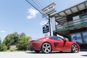
The White Wolf
we continued west, aiming to get to the Carrabasset Valley, which hosts a route that threads through the spine of the Appalachian Mountains of Western Maine. The scenery got increasingly better, with low mountains becoming high, rounded peaks. At the upper end of the Carrabasset Valley are two prominent heights of land higher than 4,000 feet - Sugarloaf Mountain (and its well-known ski hill) to the south, and the multi-humped Bigelow Range to the north. Because I did all of the 4000-footer peaks in this area as part of my northeast 111er climbing quest some years ago, I was quite familiar with this area.
Now on the western side of the range, the highway descended slightly to the resource-based town of Stratton. This town hosts a little cafe and inn that I'm quite fond of: the White Wolf. Seeing as it was generally lunch time, I suggested to my sister that we stop here for lunch. And that we did.

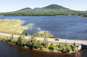
Beautiful Maine North Country
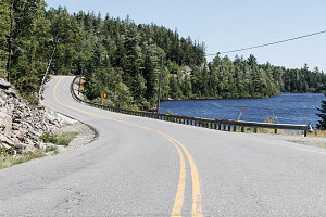
After a nice lunchtime soup (french onion soup for me, seafood chowder for my sister) and a dessert of apple crisp, we hopped back into the Cayman for the final stretch to the Quebec border. The northern Maine landscape here is quite beautiful, with expansive views out over Flagstaff lake backed by the Bigelow Mountain Range. Further along, there is a good (but short) section of twisty road along a long chain of lakes known as (unimaginatively) Chain of Ponds.

Chain of Ponds Twisty
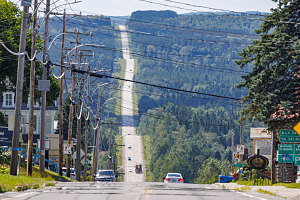
Not long after, the border at Coburn Gore came into view. Traffic was, as expected, extremely light at this fairly out-of-the-way crossing, and we were across and into Quebec within a few minutes. We soon turned left onto Quebec regional highway 212, which goes essentially straight west most of the way to Sherbrooke. Highway 212 has many long dead-straight sections of highway, passing through the occasional little french town on the way.

212 through Eastern Townships
There's not too much to say about the rest of the drive back to Ottawa. We stayed on the shortest-path route recommeded by google, skirting around the city of Sherbrooke on expressways, then onto the main A-10 autoroute leading to Montreal. And, after bypassing around Montreal, we were soon in Ontario and on the 417 back to Ottawa.
In all, a relaxing week touring New Brunswick and visiting with family. Some new roads are now under my belt, along with a new appreciation for the many pleasant little backways in the southern part of the province. Maybe I'll have to visit my brother Carl more often. Many thanks to Alphonse, Dolores, Carl and Line for their hospitality and accommodations over our week-long visit. And thanks to Matt and Phil for squeezing in an hour-long lunch visit. Great to see you guys.
And... that's a wrap. Thanks for reading this far!
Interactive trackmap with photo points - NB Road Trip July 2025 - click map to view
July 2025 NB Visit - Trip Data
Start Time:
5:35a.m.
End Time:
8:15p.m.
Duration:
182h39m
Distance:
2839.01 km
(1764.08 mi)
Average Speed:
15.5 km/hr
(9.7 mph)
Start Elevation:
263ft
(80m)
*
Max Elevation:
2049ft
(625m)
*
Min Elevation:
-42ft
(-13m)
*
End Elevation:
192ft
(59m)
*
* : +/- 75 feet
Total Elevation Gain:
25671ft
(7825m)
*
Total Elevation Loss:
25729ft
(7842m)
*
* : +/- 75 feet
Elevation Graph