Southern Ramblings
Exploratory wanderings with my brother and the P-Car - July 17, 2025
On our third day in Fredericton, I was feeling the exploratory itch. It was forecast to be a beautiful day, a responsive, nimble sportscar sat in the garage, and there were a lot of unkonwn little roads that my pre-trip research had identified. I wanted to feel the purr of a naturally-aspirated flat-six, the snick of a well-timed second-to-third shift, the view of an undulating and curving farm road visible between two Carmine Red fenders ahead of me.
I asked my brother Carl if he'd like to be my co-pilot for the day. I explained that I wanted to explore a few of the back roads in the lower basin of the Saint John River, then over to a loop of the Fundy Trail Parkway, and then back up to Fredericton via a different set of back roads. Carl was keen, and it was a plan.
We didn't have a precise route marked out. I had more of a general sense of heading south from Fredericton along the Saint John River, keeping to the back roads that looked most likely to be curvy but while still being paved. The region of the lower Saint John River is an interesting cross-hatchery of long watery inlets and bays, with hilly farmland in between. Connecting across these waterways were numerous car cable-ferries - all free and all with very short crossing times. These would be cool to incorporate into our explorations.
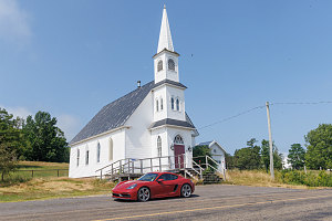
Queenstown Baptist Church
We drove along the south side of the Saint John River from Fredericton, soon passing through the satellite city of Oromocto. We soon hopped onto NB 102, which wound pleasantly through farmlands bordering the Saint John River, which was frequently visible across open fields to our east. The road was quiet and uncomplicated, and was a good spot to give Carl a chance to experience a try at the Cayman. I pulled over and we switched seats. After a general overview of controls and seat positioning, and made it a point to highlight a couple of items related to the clutch and the gear-shift mechanism. Overall my message was this: try to shift with a light touch - "man-handling" the shift lever will greatly increase the likelihood of selecting the wrong gear. I also stressed that the short shifter and short gearing meant that faster was better. The revs drop quickly off-throttle in this car, and before you know it, you are below the proper engine speed necessary to smoothly engage with the next gear.
After an initial stall, Carl pulled off onto the highway. His first few shifts were understandably slow and therefore a little jerky, but he soon got better at that. He did seem to have a problem with the two-to-three shift, often going from two-to-five instead. Again, it was all about lightness. I tried to teach my "two-finger" technique, where one applies only a tiny amount of sideways force and let the stick-centering spring assist in guiding one from one gear position to the next.
We stopped at a few spots for scenic shots of farmland and old buildings and the river. We decided to cross over the Saint John River on a cable ferry at Evandale, where a beautiful old original inn is located. The ferry was ready to go just minutes after we arrived, and with a careful diagonal approach to the loading ramp, the -20mm SPASM-equipped Cayman GTS 4.0 was safely in the middle of the little vessel.
A brief crossing of the Saint John
Within a few minutes, we were on the other side of the river, and soon unloaded onto the next bit of our route: NB 124. The roadway was still pleasantly empty, and quickly climbed up a steep hill and opened onto rolling upland farm fields, with beautiful distant views ahead.
Within minutes we were at the banks of BelleIsle Bay (another side arm of the Saint John River), and came across another cable ferry, and again, we were loaded and cast off within only a few minutes. With rapid crossing times and no ticketing, these cable ferries are quite rapid and easy to use. Carl and I got out of the car to feel the fresh river breeze wash over us as we crossed. The view up Belleisle Bay from the middle of the crossing was very scenic.
Once on the far side (at a spot called Long Point), we turned roughly east. The first phase of our driving day was more or less done. Next, I wanted to head over to the west end of the Fundy Trail Parkway - a newly-created scenic parkway that dances along bluffs above the Bay of Fundy.
Carl had a special interest in this part of the journey. Pre-retirement, he worked for NB Tourism and had played a key role in the design and development of the Fundy Trail Parkway. When I proposed doing a loop of the parkway from the western end, he expressed some concern. "There's gonna be some unpaved roads", he said. But, in my pre-trip research, I had pored over satellite imagery (there are no street views in the area) and it *seemed* to me like the crucial/necessary backroad leading south from the hub city of Sussex was paved. I couldn't 100% sure because of the low resolution of the imagery, but it looked paved to me. I argued to Carl that since he retired, more infrastructure work could have been done on the parkway approaches. He was slightly skeptical, but agreed this was possible.
So... off to Sussex. We passed by the location of my friend Shannon's family cottage compound (which we stayed before the start of our
2022 Fundy Footpath backpack), then continued on via whatever backroad or highway worked best to get us to Sussex.
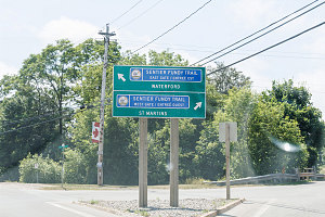
Point-on-a-loop
As we finished our drive through the streets of Sussex and approached the backroad that would connect us down to the western end of the parkway, we came across a neat sign: a kind of this-way-or-that-way sign with respect to the Fundy Trail Parkway. From this point, each end was equidistant. Carl expressed some surprise at this sign, saying that it certainly wasn't in place a few years ago. Perhaps a good sign that infrastructure improvements were indeed in place and that our upcoming backway was now paved? I hoped so.
Carl had been calling this backway "The Shepody Road" - which seemed reasonable enough, since it did go through a no-building community called "Shepody" on the map. But the map also calls the road "Creek Road", for some reason, and labels a different nearby road as "Shepody Road". In any case, the road - whatever it is really called, started off paved and... stayed paved. Long after the last house on the outskirts of Sussex had past, the road was still paved. And nicely-paved, too. Carl had speculated that even if it was surfaced, it would be rough and loose - a method I like to call "chip-seal". But no, as we drove, this looked and felt to me like genuine real asphalt. The road undulated and curved and had some nice esses. It wasn't super tight like a West Virginia twisty, but it was pretty fun. and devoid of other cars. And the speed limit was reasonable. I pushed the Cayman a little harder and I think Carl tensed up a little, but the unflappable chassis of the Cayman made quick work of the curves, and soon he seemed more impressed than anxious.
Once we were more than two-thirds of the way down Creek/Shepody Road towards its join point with the Fundy Trail Parkway, it seemed fairly clear that the whole thing was paved. Indeed things had improved since Carl had retired from his job.
This area of southern NB is - unlike the areas around Fredericton and Saint John - pretty devoid of farmland or habitation. There is one bit of civilization, though - a backcountry lodge and rental huts known as "Adairs Wilderness Lodge". Apparently it has been a popular spot with ATVers and snowmobilers over the years - but now with paved access and the newly-built Fundy Trail Parkway nearby, they are probably expecting a big uptick in business.
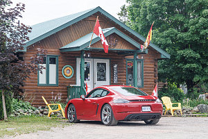
Adairs Wilderness Lodge
Carl knew that this place had a functioning restaurant, and suggested we stop here for lunch. I would have driven right past, as today - the place seemed dead. There was one other car in the large parking lot. We walked into the super-rustic cottage-like main building, and the dining area was also nearly empty - two people were sat at a table in one corner. But the waitress was indeed there, and she was cheery, and soon we were reviewing the menu and getting ready to order our lunch.
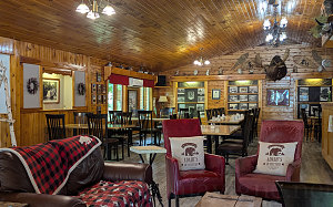
Adairs Interior
Time was drawing on (we had promised to be back in Fredericton for dinner at 6pm), and so we didn't dally. Lunch was soon done and we were back on the road, continuing south towards the Fundy Trail Parkway and the Fundy coastline.
Within minutes we intersected the main eastern connector road to the Fundy Trail Parkway (which itself connects further east to a spot near Fundy National Park). We continued straight, continuing south. Immediately the pavement changed - from a light gray to a dark black, with freshly painted center and side lines. We had unofficially reached the eastern end of the Fundy Trail parkway. Immediately the character of the road bed changed. There were wide verges and large, well-graded ditches, and the vegetation line was cleared much farther back away from the road. The cutouts the roadway made through the landscape were much more prounounced and set back. Carl pointed out that the parkway had been engineered to the latest highway-class standards. You could immediately see that.
What was less great was the road surface. Although it was new, it was clearly chip-seal (as in, it had been laid down loose and the passage of traffic had consolidated it). Once this happens, it is fine for sporty driving, but the texture of these kinds of pavements is such that they are very loud. In this case they had applied a layer of black tar on top of the surface post-consolidation, but still, it was a coarse surface. Immediately the noise level in the Cayman was up by several dB.
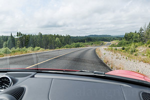
Wild and Untouched
We cruised along at a pleasant 80-90 km/hr in this section, enjoying the solitude and gently rolling landscape. There were no other cars to be seen - which was nice, but also a little unexpected. Soon we came across the official eastern entrance kiosk, where one must stop and pay an access fee (and receive some park literature, presumably).
We pulled up behind a minivan that had been having an extended chat with the kiosk attendant. Minutes passed, then more minutes, then more minutes. Looking behind us, not one car had come up behind us, really highlighting how quiet things were today. Finally, the minivan pulled away, and it was our turn.
The lady was cheerful, asked us a few questions - including our addresses, and Carl and I fumbled a bit with the fact that my address was in the province of Ontario and his was in New Brunswick. It was good that this happened, for when she got wind of the fact that Carl lived in NB, she mentioned that there was a discount for NB residents.
I'm not sure if she mentioned it specifically because of the shiny Red Porsche we were driving, but as we were pulling away, she left us with a "Don't Speed Now!". Thank you so much, and goodbye!
Now, I've known this prior, and it is why I do not consider the Fundy Trail Parkway as high as it could be on my list of "great roads" - the speed limit on the entire length of parkway between the entrance gates is 40 km/hr. Now, I get the arguments about safety and lower is better and etc etc. But c'mon. 40? On a highway-grade road with excellent sight lines? I understand there are lookouts and pullouts and one needs to be careful, but truly, this limit is way too low for this road. We slowed down quite a bit from our previous 80-90 km/hr speed, but I will be honest and say that we were still going about 50 or 55. And even that seemed dog-slow for this engineered, nearly empty highway.
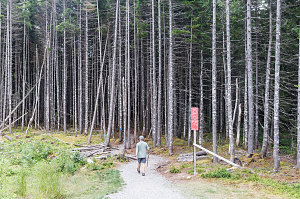
A short hike
We soon reached one of the many recreational / scenic stops along the highway - the Walton Glen Gorge / Eye-of-the-Needle access point. There's a small visitor center here and a large parking lot for visitors and hikers. There are trails that start here, including one to a gorge lookout and one that goes down into a slot canyon within the gorge (and then on down to the Fundy Footpath and the coastline).
Carl (who was driving) suddently decided that we should go on a short hike, surprising me a little. I didn't expect him to suggest that, but I was up for it. Clearly he was interested in seeing more of the progression of the parkway and related infrastructure.
The hike we chose was a simple one: a 1.1km (2.2km total) out-and back walk to the Walton Glen Gorge lookout platform. It was great to take a break from the car and hike on a fun little path through the woods. With two hiking sticks in hand (the trailhead has a little stash of poles for people to use), Carl marched off, with me in tow.
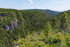
Walton Glen Gorge
I'm not sure if it was a by-product of working in the tourism industry, but I learned on this hike that my brother Carl says hello to literally every single person or party he meets on a hike. Without fail. And not a little nod - but a big, deliberate "hello / how are you doing / hope you are enjoying this great day / have a safe time / etc". Geez. I'm a mute by comparison!
The hike started off as a defined little footpath through a stand of very tall confiers - so tall that the trees' active needles were thirty feet above our heads. At ground level here it was all bare trunks - gloomy and gray but nice and cool and refreshing.
It wasn't long before the narrow footpath intersected with a much larger, gravel-packed path - wide enough that you could drive a large ATV down it. This was the main access trail to the lookout, and Carl said it had been cleared and graded this way to allow a small electric golf cart like vehicle to take accessibility-limited visitors to the lookout.
We walked along the wider easier trail, following the signs to the lookout, and saying large helloes to any and all hikers. We passed the junction of the trail leading down into the Gorge, and minutes thereafter, the lookout. The large wooden and railed deck was empty, saved for one somewhat bored-looking park employee, sitting on a small stool under a 1-person sunshade umbrella. He popped up when he saw us, immediately launching into a (very clearly oft-repeated) welcome and brief recap of the geologic history of the gorge.
It was indeed a pretty view of Walton Glen Gorge, although the views of ruggedness were somewhat muted by the tenacious vegetation, which hid much of the gorge's rocky walls. Looking downstream, there was the faintest glimpse of a slice of the sea waters of the Bay of Fundy. I was curious as to how far away that actually was, and used my Garmin GPS to take a straight line measurement. "3 kilometres", I stated. The park employee, who had finished his standard spiel, seemed interested in this number. Apparently many people ask him exactly this and he had never had it measured.
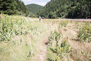
Down at the Bottom
Yep - I remembered that spot, three kilometres away, down at the bottom near the coast. A beautiful bit of meadowland, where the Fundy Footpath crosses the lower valley of the Little Salmon River (which the Walton Glen Gorge empties into). Here's a shot taken from when we were at that point on our backpack in 2022. (You can read all about that backpack
here).
After a few minutes at the lookout, it was time to head back. The trail is easy and without huge ups and downs, and we were back at the car in short order. We swapped positions back to me in the driver's seat, and we continued our drive west on the Fundy Trail Parkway.
Up to this point, we'd been driving through inland terrain - but now, within a few minutes, we arrived at the first of the lookouts directly above the coastline. And if there is one good thing that the Fundy Trail Parkway does, is give you superb lookouts over the Fundy Coastline, the first of which (in this direction) is the lookout above Seely Beach. There's an excellent view east along steeply sloping coastal woodline, with the little bump of detached Martin Head in the hazy distance.
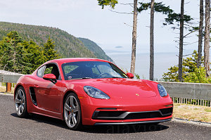
Seely Beach Lookout
From this point to its western end, the Fundy Trail Parkway is one delicious bit of tarmac, deliberately curving and sweeping and cresting up to amazing lookouts, and then diving back down in attractive curves - some quite tight - back to the coastline. Frustratingly, all signed at 40km/hr. The Cayman would have been delightful in many of these turn sequences, but we kept it fairly tame.
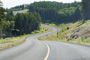
Parkway Curves
There's one particularly spectacular bit of highway - where the road heads way out to a prominence far above the sea, does a very tight more-than-180 degree hairpin, and then descends some moderately-sharp, beautifully-linked esses down. I wanted some aerial shots of the Cayman GTS running through this beautiful area, so I had Carl take over the wheel and we did a couple of up and down runs while I took shots. They capture the feel of the parkway's and the coastline's beauty well.
After a short session of aerial photography, we continued west. The parkway snakes beautifully downward through some deep rock cuts, bottoming out with a bridge crossing of the Little Salmon River. The parkway's pavement transitions from chip-seal to "real" pavement along the stretch, resulting in a noticeable reduction in road noise and tire roar (and this road surface continues all the way to the parkway's western entrance).
There are a number of attractions, pullouts, and visitor centers along the final western stretch of the parkway. We didn't stop at any of these, though, as we were running up against our get-home time of 6pm.
The speed limit transitioned back up to 80km/hr at the western entrance to the parkway, and we were able to make better time. We continued along the coast until the town of St Martins, stopped to take a car selfie in front of the soft red sandstone formations visible here, and then turned north to follow the shortest course of backroads back up to Fredericton, arriving back at 6:15pm, only 15 minutes beyond our promised time.
In all, the day had turned out to be a really fun excursion with my brother - a nice mix of driving fun, sightseeing, exploring, and physical activity. Thanks, Carl!